Salt of the earth: an alternative side to Cheshire
On her camping road trip through Cheshire, Caroline Mills discovers a county as surprising as it is beautiful.
‘I laid the stone paving path to White Nancy many years ago,’ says Mr Bullock, Cheshire’s most iconic landmarks that I’m looking forward to visiting following a stay at his riverside farm campsite, and I’m keen to gain local knowledge.
Cheshire has recently been associated with wealthy footballers’ mansions and not-very-real housewives. It’s not an aspect I’ve come to the county of cheese and grinning cats to investigate, preferring a solitary walk amid green fields and a heritage that goes back longer than ITVBe’s second-highest-rated programme. It didn’t take long to find an alternative side.
The route
The Peak District National Park
As a tourist catchment area, Cheshire is extraordinarily underrated. For example, the most eastern locale of the county is situated within the Peak District National Park. It’s here that I begin, with a stay at Jarman Farm. I spy walkers on the hill above the CS and, though it’s difficult to prise myself away from the soothing murmurs of the River Bollin beside my pitch, I venture on a circular four-mile trek that introduces me to the undulating terrain and views – of parkland meadows, moors and the giant Lovell Telescope at Jodrell Bank – afforded by an evening stroll along Birch Knoll, east of Macclesfield (or ‘Macc’ as Mr Bullock likes to call it).
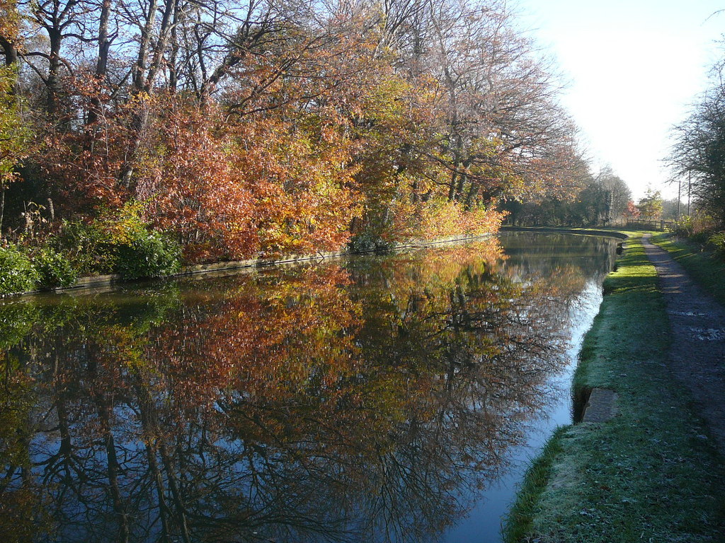
The Dane Valley
It’s the hottest day of the year as I approach the coolness of the Dane Valley, Cheshire’s border with neighbouring Staffordshire, on a short road trip the following morning. The idyllic wooded dell, with historic stone bridge and microbrewery riverside, coupled with a water’s edge footpath, is far removed from the county’s Golden Triangle. This is the real Cheshire, where the natural folds of the hills are tight and contorted.
Passing through the remote Peak District village of Wincle, I continue north along the valley to the distinctively named Wildboarclough. It’s no more than a couple of houses and a pub, the Crag Inn, beside a rocky gorge of red sandstone amid trees. The sheltering canopy of leaves are refreshing but once in open countryside, with the heat rising, I shy away from climbing Shutlingsloe, the ‘Matterhorn of Cheshire’, despite the magnificent views of Cheshire’s Peak District, instead preferring refuge from the sun in Macclesfield Forest.
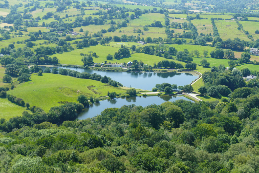
The forest, of oak and ash, beech, sycamore and larch, is uplifting, and there are footpaths and bridleways aplenty through the trees to explore. But I stand still in bewilderment at the beauty of Trentabank Heronry, a nature reserve managed by Cheshire Wildlife Trust that is, arguably, the most restful spot in the county. The lake (strictly speaking a reservoir) is surrounded by larch trees used by herons for breeding. Bracken, meadowsweet, wild carrot, foxgloves and willowherb sweeten the air around the banks while herons drift undisturbed beside beds of water lilies.
I pass several lake-like reservoirs on my way to Tegg’s Nose Country Park. There’s a bruising climb to the summit of Tegg’s Nose from its foot in the village of Langley, but a gentler option is to start a walk from the car park of the Country Park to reach this distinctively shaped snout. Views are notable, of Macclesfield Forest and the chain of reservoirs in one direction and the jigsaw of Manchester’s high-rise buildings in the other.
White Nancy
My miniature road trip takes me north again, between the rounded hills of Cheshire’s Peak District towards Bollington and the elongated Kerridge Hill. White Nancy sits at the northern end of the hill; it’s possible to approach from the south along the Saddle of Kerridge. Despite the swollen sun, I choose the short but sharp option from Bollington – up the very paved path laid by Mr Bullock.
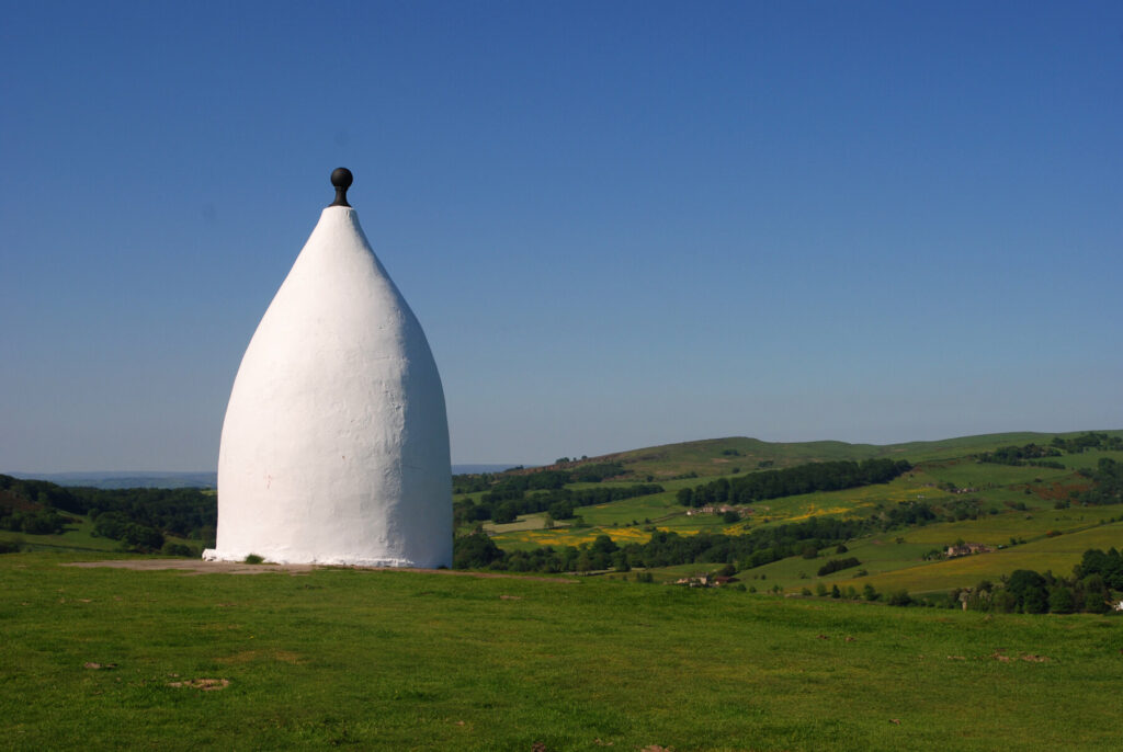
I’m grateful for his efforts for, at the top, White Nancy – a rotund stone obelisk created in 1817 to celebrate victory at the Battle of Waterloo – gives reason to sit for a while and take in yet more of Cheshire’s fine views, including the former cotton mills in Bollington, a hint at part of the county’s heritage.
The Plain: Northwich, Middlewich and Nantwich
Cheshire is a landscape of two halves, with a marked difference. In the east – my first day’s travels – are rounded hills, burbling streams and appealing villages made up of stone cottages. It’s very rural and feels remote. In the west, the Plain. There’s nothing ordinary about it, but the flat, open landscape makes way for wider rivers, canals and brick-built towns rich with industrial history.
I choose to explore the Plain via a trio of ‘wiches’, three towns that line-up north to south, each with a canal (or two) and an important history of salt production. With an overnight stay at Shrubbery Cottage CS in the village of Comberbach, I take the opportunity of its location for an early evening wander to explore the rural north of Northwich. From the CS, it’s an easy walk along the North Cheshire Way, through extensive Marbury Country Park and along the towpath of the Trent and Mersey Canal. I pass by the ingenious Anderton Boat Lift, which allows boats to navigate both canal and river – the Weaver Navigation.
The extensive expanse of meadows, woodlands, nature parks, lakes, canals and rivers creates Northwich Community Woodlands, growing on reclaimed wasteland established by the salt and soda industries. The formal parkland avenues of trees and picnic areas surrounding Budworth Mere in Marbury Country Park contrasts with the wild meadows and woods. On my return walk to Comberbach, the child in me finds it a welcome treat to syphon off a pint of milkshake from the Milkbot at Home Farm as I pass by, the very herd of cows that supply the milk in full sight.
Northwich, as its name suggests the most northern of the ‘wiches’, is a waterside town of converging rivers. While there’s a rather shabby looking 1960s market hall building in the centre and a more gleaming riverside glass-and-steel construction at the newly built Baron’s Quay (a pleasant place to sit for a drink), there are plenty of black-and-white timber buildings for which Cheshire is notably renowned. A brief history is gleaned with visits to the Weaver Hall Museum (the town’s museum, housed in a former workhouse) and the Lion Salt Works, in the suburb of Marston, on the edge of town.
Cheshire is famous for its exceptional rock salt and there were once many mines around Northwich and the surrounding area. Lion Salt Works, the last open-pan salt plant left in the UK, harks back to a hot and sweaty industry as depicted throughout the museum. The collection of brick and timber buildings beside the Trent and Mersey Canal, along with a series of flashes (lakes that swallowed up former mines as they collapsed beneath the water), offer an attractive glimpse at a not particularly appealing occupation.
My final day in Cheshire is experienced canal- and river-side, first in Middlewich, where the Trent and Mersey Canal and the Middlewich Branch of the Shropshire Union Canal merge.
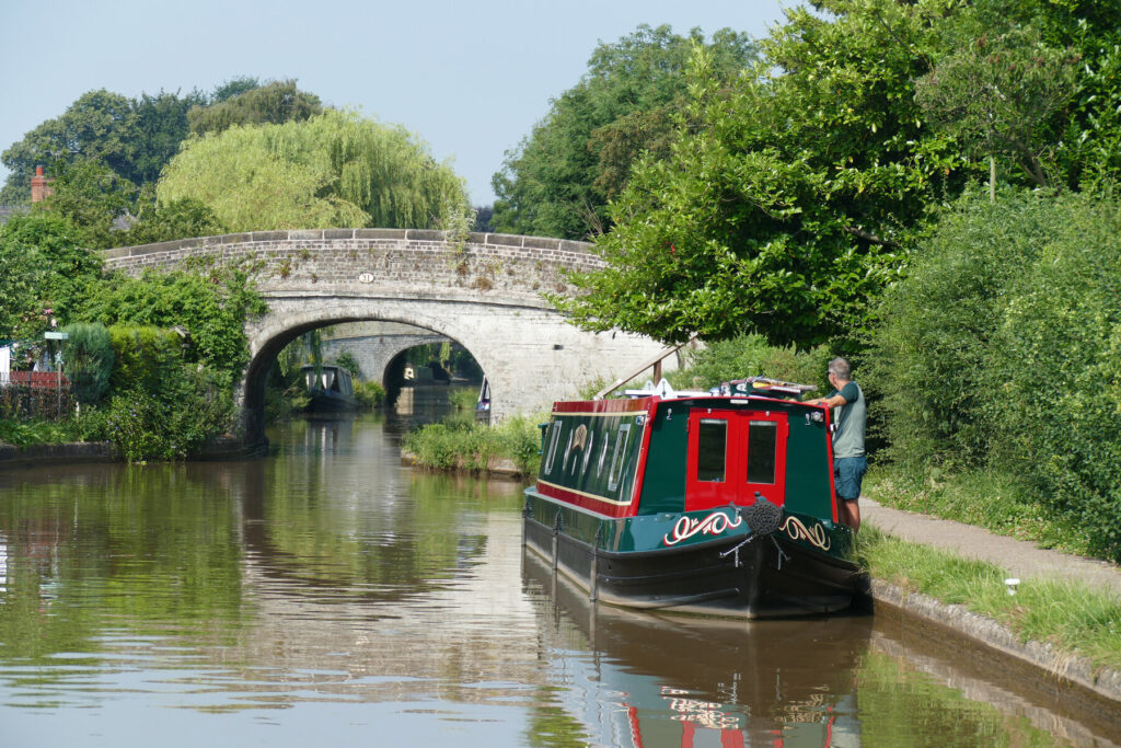
There’s not a great deal to keep a tourist in Middlewich for long, unless the day is spent walking the towpaths – by no means a bad way to spend the day, particularly along the Shropshire Union Canal, which appears the more appealing of the two. But beyond a short browse of Middlewich’s High Street (taking in the Art Deco façade of the former Alhambra cinema) my preference is to spend the greater amount of time in Nantwich, the most southerly of the three ‘wiches’. In my humble opinion, I’d left the best of the three towns until last.
There’s a goodly assemblage of monochrome timber buildings, a café culture within the pedestrianised centre (including an excellent bookshop-cum-café) and an impressive parish church. There’s also the three-mile Nantwich Riverside Loop, a circular walk that takes you out of town along Welsh Row, a historic street of Georgian merchants’ houses, before bringing together the Shropshire Union Canal and River Weaver, which flow either side of the town.
I spend 72 hours in Cheshire. I’d happily spend many more, especially if they happen to be at my final stop of this trip, Snugburys Ice Cream. There’s a selection of 30 or so flavours to be indecisive about at the farm ice-cream parlour and my eventual choice is one of the creamiest, most delicious ice creams I’ve ever had, made all the tastier while wandering through the wildflower meadows on the farm. Honeycomb or Cherry Blizzard? Hmmm, now there’s a decision to be made.
Practicalities
Getting there and around
A537 Macclesfield; rural lanes around Sutton, Wincle, Wildboarclough, Macclesfield Forest & Langley to Tegg’s Nose Country Park. Then north to Rainow & Bollington. A523 to Macclesfield; A537 to Knutsford; A556 then A559 & rural roads to Comberbach. A533 to Northwich & Middlewich; A530 & B5074 to Nantwich. (Snugburys Ice Cream is a detour, 3 miles north of Nantwich on the A51.)
At Northwich, there’s parking at Victoria Club Car Park, Weaver Hall Museum & Lion Salt Works. On-street parking available everywhere in Middlewich. At Nantwich, try Snow Hill Car Park or Lakeside Parking.
You can find more information on the Cheshire Tourist Board website.
More information
For more information, see Caroline Mills’s book: