The best natural wonders in Western Australia
Experience some of the world’s most diverse and dramatic landscapes.
Western Australia is home to some of the most jaw-dropping landscapes in the world. From million-year-old rock formations and glistening coral reefs, to magnificent chasms and picturesque beaches, here’s what not to miss.
The Pinnacles
The darlings of a million tourist pamphlets, the Pinnacles are the centrepiece of Nambung National Park – thousands of thin limestone towers (up to and over 4m) that have spawned up out of the orange sand. The landscape here has been compared to the moon or the set of a science-fiction film, but even those descriptions don’t do it justice. Surrounded by Outback scrub and huge white sand dunes on one side and the Indian Ocean on the other, they do look remarkably out of place. Perhaps Mad Max meets The Beach is a better fit.
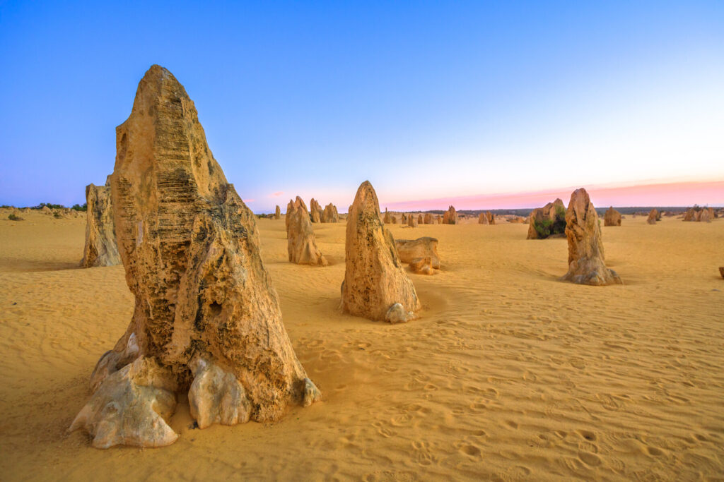
Scientists believe that the Pinnacles were formed from quartz sand dunes that stood atop limestone and lay inland from the coast, some 25,000 to 30,000 years ago. As cracks formed in the limestone, this was gradually filled by plant roots, water and sand, all of which eroded the limestone – when the wind eventually carried away the detritus, the Pinnacles were revealed. A walking trail and a sealed, 2WD- and wheelchair-suitable road lead through the park. Both start from behind the Pinnacles Desert Discovery Centre, which has displays and exhibits chronicling the geology of the national park.
Ningaloo
Although its big brother, 70km off North Queensland, gets all the attention, the Ningaloo Reef is in many people’s eyes even better than the Great Barrier. It is certainly one of Australia’s most underrated gems – its isolation, located in one of the country’s least-populated areas, has protected it from overdevelopment and crushing tourist hoards. While the Great Barrier is bigger, Ningaloo is a lot more accessible – as a fringing reef, rather than a barrier reef, it extends much closer to the shoreline and in many places you just walk into the water off the beach and you’re there.
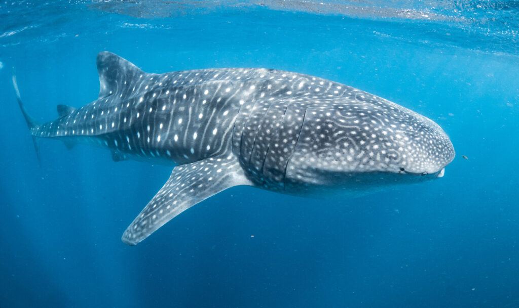
The largest reef in the world near a land mass, at 300km long, it became UNESCO listed in 2011 because of its incredible biodiversity – it is home to over 200 species of coral and 500 animal species. The area is most famed for its gentle whale sharks – the biggest fish in the ocean with a mouth over 1m long. Best seen between March and August, their distinctive polka-dot pattern – white spots on grey skin – is unique to the individual, in the same way no two snowflakes are alike. Ningaloo is also just one of two places in Australia where you can swim with humpback whales.
Wave Rock
Rising unexpectedly and dramatically out of cleared farmland or eucalypt scrub, Western Australia’s granite outcrops – scattered in isolation across the region – are millions of years old and form part of one of the world’s most ancient landscapes. Created from magma solidifying under the earth, before becoming exposed through eons of soil erosion, these golden-brown domes look jarringly and intriguingly out of place against the surrounding flat agricultural land.
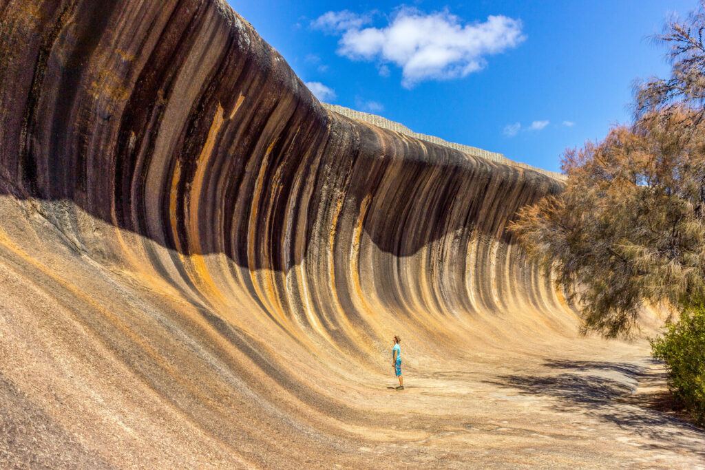
The best-known outcrop is Wave Rock in the town of Hyden, famous for its distinctive ‘surf wave’ shape and vertical streaks. There are hundreds, perhaps thousands, of rocks scattered across the whole region, and in recent years a two- or three-day self-drive circuit around the Eastern Wheatbelt has become a popular road trip. The vast majority of rocks are 2WD-accessible on good roads, and almost all of them have walking trails leading to the top that can be done in under an hour. When you see a small tower or stack of pancaked rocks, you have reached the peak.
The Bungle Bungle Range
On the UNESCO World Heritage List since 2003, the magnificent beehive-resembling orange-and-black sandstone domes of the Bungle Bungle Range are the highlight of Purnululu National Park. Some reaching 250m in height, the domes themselves are made of sandstone, and were carved out of erosion from waterways. The distinctive striping is due to cyanobacteria, which require moisture. The darker stripes have their presence, while the orange bands indicate areas of dryness that can’t support the cyanobacteria.
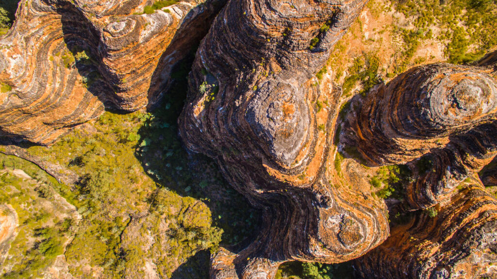
Sometimes Bungle Bungle is used synonymously with Purnululu, but that is a mistake – Bungle Bungle is a range within Purnululu, and the park itself is several times larger. The park is split into two sections – northern and southern – and try to plan your itinerary so that you have ample time to explore both. However, if you have time to do only one side, then make it the southern section – where you can explore the dramatic Cathedral Gorge as well as the beehive domes.
Mount Augustus
This is often called the largest rock in Australia, but that is not technically accurate – Mount Augustus is actually an anticline in geological terms. But rising 715m above the surrounding land and 1,106m above sea level – compared with Uluru’s 348m and 863m respectively – Mount Augustus is a whopping 8km across, 1.6 billion years old (almost a billion years older an Uluru), and certainly something you will never forget as long as you live. Also unlike Uluru, the tourism industry is yet to really discover Mount Augustus, so you will have the place (more or less) in splendid isolation.
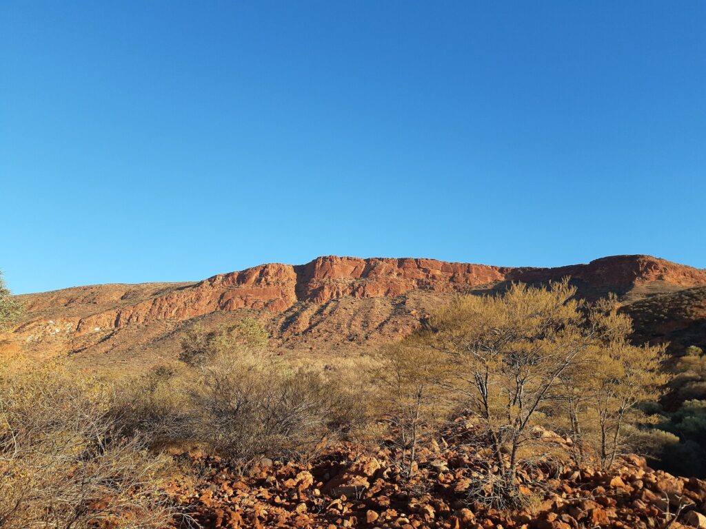
Surrounding Mount Augustus is the Kennedy Range National Park, criss-crossed by a dozen or so walking and driving routes. The 49km Loop Drive takes you around the entire base, while the Summit Trail (12km return; Class 4) walk offers amazing views over the surrounding bush. Aboriginal engravings can be found along the Ooramboo Trail (500m return; Class 3) and at Mundee’s Petroglyph Trail (Class 3,300m return).
Shell Beach
Just north of Shark Bay Road, midway between Denham and the highway, is the unique Shell Beach made up of millions of Fragum cockle shells, which have thrived because the hypersalinity of the water has made the habitat unsuitable for many predators.
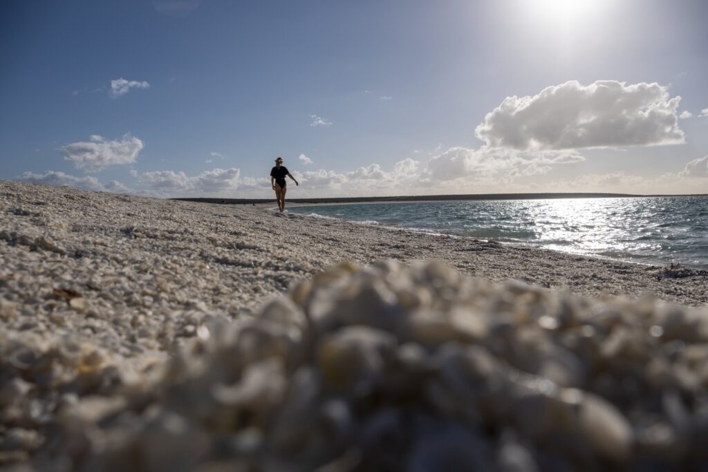
At some points, the depth of the shells is more than 10m – you are free to go into the water here. A further 30km from Shell Beach is Eagle Bluff, where a beige sandy cliff descends sharply down to the blue green sea, which is good for snorkelling. A 400m boardwalk next to the lookout car park provides a great vantage point for spotting marine animals.
Wolfe Creek Crater
The second-largest crater in the world – 880m across, and roughly 60m deep – Wolfe Creek is the site of a meteorite impact, around 300,000 years ago. Europeans first sighted the crater during an aerial survey in 1947, but Aboriginal people have known about it for much longer; they believe a giant snake emerged from the ground to help create the Wolfe Creek and Sturt Creek.
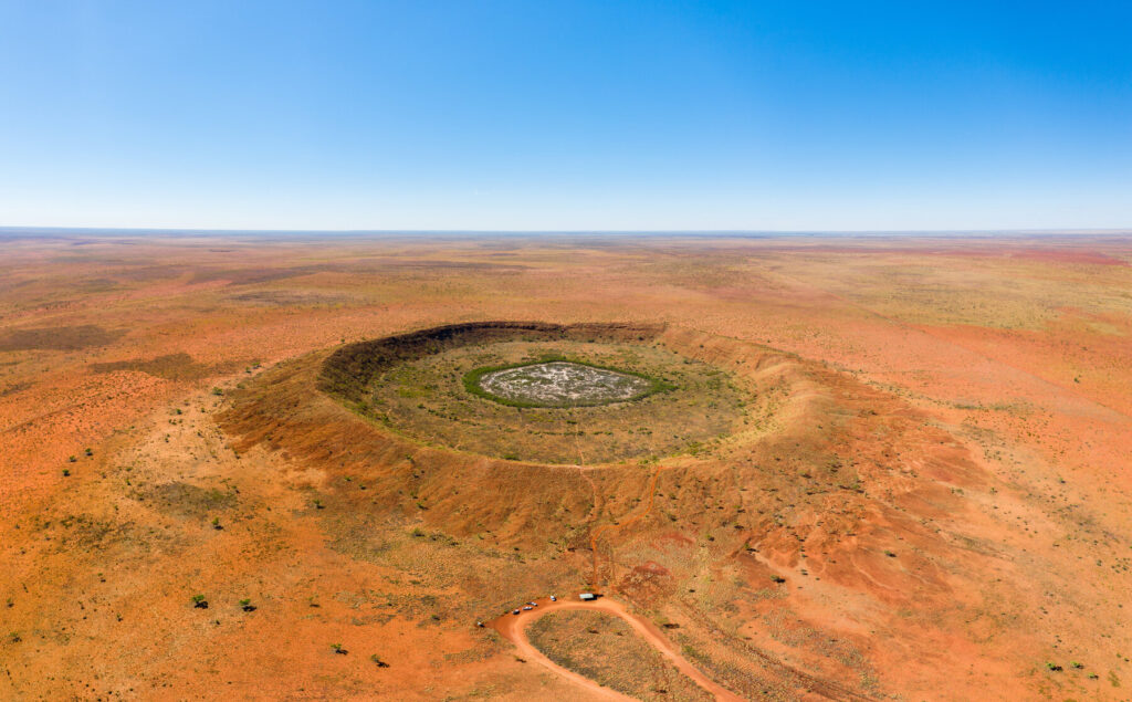
It is an impressive yet eerie sight to come across this gaping circular hole in the middle of a flat Outback landscape. While you are not allowed to climb down the crater, you can walk up to the rim (a difficult 400m climb) or take a 70-minute scenic flight over it with Northwest Regional Airlines departing from Halls Creek. You can camp at Wolfe Creek Crater – though you need to be completely self-sufficient. Access (4×4 only) to the national park is along Tamani Road, about 150km/2 hours south of Halls Creek.
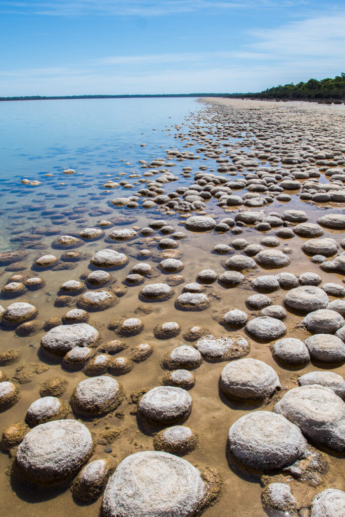
Lake Clifton
Nestled between the Forrest Highway and the Indian Ocean, the 12,000ha Yalgorup National Park is the largest national park in the Swan Coastal Plain. Part of a large wetlands system, it is dotted by ten lakes – most notably Lake Clifton, known for its thrombolites (rock-like structures built by microorganisms (too small to see) that are related to some of the oldest living things on earth). Thought to be 2,000 years old and the largest example of thrombolites in the southern hemisphere, they are best viewed from the shoreside boardwalk as you can get up close to the thrombolites without damaging them. Mandjoogoordap Dreaming offer guided tours to the thrombolites and their place in creation stories and Aboriginal culture and history.
Other activities in the park are limited due to the fragile nature of the ecosystem – walking is permitted, but use of the lakes for swimming, boating, canoeing and fishing is not. While the trails through the woodlands are perfectly pleasant, this is not considered to be one of WA’s showcase national parks – indeed, many visitors have never heard of it until they pass the sign for it on their way from Perth to Bunbury along the Forrest Highway.
More information
For more information, check out Scott Dareff’s guide: