One of the myths of Western Australia is that it is inaccessible – that to do a trip here justice, you need a massive 4×4, a month off work, and a whole lot of money. But this is all completely untrue.
Scott Dareff, author of Western Australia: the Bradt Guide
Western Australia is full of oddities and superlatives. If the state were its own country, it would be the tenth largest in the world – yet outside the Perth Metropolitan area, there are no towns with over 100,000 people. There have been times here where I have driven for 8 hours and not passed another town – and if you drive the nearly 700km stretch between Collie in the South West and Kalgoorlie in the Goldfields, you won’t pass a single traffic light.
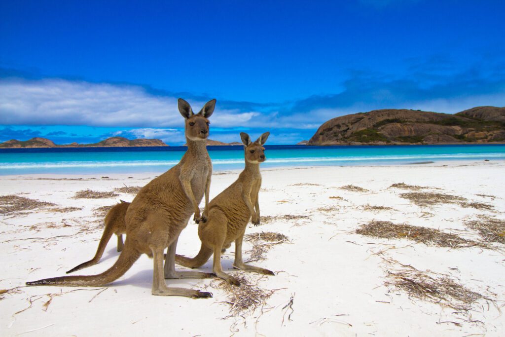
Many people equate WA with the vast, empty landscapes of the Outback – and it is true that much of the state is taken up by desert. But it would be wrong to equate the sparsely populated landscape with a sense of nothingness. Indeed, some of Australia’s most spectacular attractions are found in the west. Ningaloo Reef, the world’s largest fringing reef at 300km long, is every bit as astounding as the more famous Great Barrier Reef – and far more accessible, as you can just walk off the beach into the water and among the reefs and marine life. Up north in the remote Kimberley, Karijini’s magnificent gorges have earned it a well-deserved place in the Australian psyche as one of the nation’s finest national parks. You can also head east and prospect for gold and precious metals in some the world’s most productive goldfields – and keep what you find.
And there are plenty of other landscapes to explore besides endless red dirt. The fertile southwest is known for its magnificent jarrah and karri forests, home to some of the tallest trees on earth, while one of the world’s biggest and most dazzling displays of wildflowers appears every spring throughout the state – with some 12,000 species, 60% of which are found nowhere else. In the Mid West, the Great Western Woodlands – spanning some 16 million hectares – are Australia’s lungs, the largest (and healthiest) remaining temperate woodland on the planet. The state is also known for its remarkable rocks – the massive striped granite outcrops in the Wheatbelt look like giant waves, while the eerie limestone pinnacles at Cervantes are reminiscent of a moonscape.
Perth itself has a reputation for being a relaxed and tranquil city – the sort of place where one of the biggest attractions is sitting back with a coffee at one of the many promenades strung along the city’s dozens of sparkling beaches. It’s also Western Australia’s eating and drinking hub, and the Cappuccino Strip in Fremantle, where innovative eateries and trendy bars line the historic main drag, is the best place to do so. The city’s signature highlight, however, is Kings Park, one of the nation’s best botanical gardens – a good place to acquaint yourself with banksias, kangaroo paws and many others of the state’s native flora.
The state is an excellent place to learn more about Australia’s Aboriginal heritage, as this this was one of the first places Aboriginal people settled in when they arrived in Western Australia 50,000 years ago. Aboriginal art here is some of the best in the state, but the premier site is undoubtedly the Burrup Peninsula, home to rock art that is thousands of years old. Gazing at some of these ancient drawings, you can’t help but wonder if some of the animals you can’t quite recognise are actually extinct.
For more information, check out our guide to Western Australia:
Food and Drink in Western Australia
Food
Some of the world’s finest produce comes from Western Australia. The state’s 12,000km of coastline produce outstanding seafood bounties – barramundi is a favourite in the Kimberley, Mandurah is known for its crabs and the area along Indian Ocean Drive is a haven for rock lobster. The South West’s and Great Southern’s cattle farms produce outstanding beef, and their dairy produce lends itself to exquisite cheeses. Apple and stonefruit orchards dot the Donnybrook and Blackwood Valley regions, and the inland South West, Peel, Swan and Chittering Valleys are known for citrus. Manjimup has an annual cherry festival and also produces award-winning truffles. Carnarvon has delectable bananas and tropical fruits. The state’s wheat, canola and barley crops are exported all over the world, as is lamb from WA abattoirs – the Middle East being a particularly voracious market. West Australian honey, produced seemingly all over, is also top-notch. Many areas of the state have farm gates open to the public and going from orchard to orchard or farm gate to farm gate is a relaxing and delicious past time.
For those seeking some WA ‘comfort food’, good go-tos are South West marron linguini, fish and chips with something locally caught (impossible to say what – if it’s fresh, it will be whatever’s just been caught!), or a good old-fashioned scotch fillet steak from a South West cattle farm. A pavlova – an Australian meringue dessert topped with fruit (usually berries) and whipped cream – is an excellent finish with a South West or Great Southern port.
Eating out
Like any large Western, developed city, Perth has a range of dining options from high-end, five-star restaurants to fast-food outlets. The state’s Italian and Asian heritage is reflected in its vast number of quality restaurants, although many others tout their use of West Australian products. Vegetarians and vegans will have no problem in the Perth Metropolitan Area, but outside the capital area and some parts of the South West you may struggle to find a wide variety of options and should plan ahead – many places have menus or Facebook pages with some of their dishes online, and ringing ahead and asking will be helpful. Be sure to tell staff of any dietary requirements when you arrive.
The pub is still the lifeblood and hive of activity in country towns, sometimes branded as a tavern. In some places it might be the only place to get a meal. Most pubs and taverns will have a bar and then a separate dine-in family section; some also offer simple accommodation. Pubs serve hearty meals and should be tried at least once – though quality can range from excellent to inedible, and menus often vary little from one town to the next. Finding a good one can be a trial-and-error process.
On the highways, roadhouses and petrol stations will often offer dine-in and take-away coffees, cakes and filling fare like burgers and all-day breakfasts; some are tasty, but others are so greasy the bag it is in looks like it will dissolve.
Vegetarians may be inconvenienced in smaller towns – limited to a few puny options on pub menus. It may be worth it to plan ahead and locate IGAs where you can buy vegetables and protein to make your own meals, or peruse menus online first and plan ahead.
Dishes highlighting bush foods that Aboriginal people have used for thousands of years, like wattle, native lime and other plants or meats like kangaroo, have made exceptionally limited headway into Australian menus – you are not going to find an ‘Aboriginal restaurant’ and will struggle to find restaurants or cafés that use any bush foods at all. You may very occasionally find a place serving kangaroo steaks, usually made from the meat in the tail – this is a very high-quality meat with low fat content, usually served medium-rare and well worth trying.
Drink
The state is also famous for the high quality of its premium wines. Margaret River is the most well-known wine region, but most of the South West, Great Southern, Peel and Perth regions produce vintages. Margaret River is well-known for its Cabernet Sauvignon and Shiraz, while the Great Southern has outstanding Rieslings – visitors never fail to come back with a few bottles whenever they’re in Albany or the Porongurups. The Swan Valley, on Perth’s northeastern fringe, is the state’s oldest wine region – try the Chenin Blanc here – and the Perth Hills produce a number of good varieties. There are also wine regions around Busselton, the Blackwood Valley and Pemberton/Southern Forests – the fortifieds and ports that come out of the Blackwood are particularly memorable.
Numerous craft breweries cover the state, there are some good rum distilleries in the Mid West and Kimberley, while craft gin is also becoming big business. If you aren’t into alcohol – Australians are proud of their coffee and tea palettes – you will have no problem finding a caffeine fix anywhere in the state. A ‘long black’ is a double espresso in hot water – the espresso is poured over the hot water instead of the other way around, as in an americano. American-style filter coffee can be hard to find, however, and you may need to explain to the barista what you want and see if they can do it (or if there is a close substitute). Bottled water is abundant and for sale everywhere, though the tap water is safe to drink.
Health and safety in Western Australia
Health
Western Australia is fully developed and has a comprehensive health-care system. Your main health risks are likely to come from sunburn, heat exhaustion, exposure to the elements, and in some areas, mosquito-borne viruses such as Ross River virus.
Safety in the sun
The sun in the southern hemisphere is like a microwave, and if you are coming from the northern hemisphere, you will not be accustomed to just how quickly and severely you can get sunburned here (especially in summer). A period of time that you can spend outdoors in Europe or America with no problem will turn you into a lobster here. Australia has one of the world’s highest rates of skin cancers from UV exposure.
‘Slip, slap, slop’, a slogan referring to wearing suncream, became a national tagline in the 1980s, and make this a personal mantra. Cloudy days do not reduce the risk of UV or sunburn – the rays just penetrate right through them. Carry suncream, sunglasses and a wide-brimmed hat with you at all times, and reapply the cream at regular intervals. Ideally use at least a factor 25 (preferably higher) to protect against the UVB rays and ensure that it has a five-star UVA rating too.
Nationally, heatwaves cause more deaths than bushfires and storms combined. Heat-related illnesses occur when sweat alone is not enough to keep your body cool, whether that’s because you can’t sweat enough or because the conditions are too extreme for your body. Symptoms of heat stress include headaches, dizziness, fatigue and tiredness, cramps, feeling less thirsty and urinating less. Rest in a cool area, drink water, remove excess clothing and apply a wet cloth to your skin, particularly the armpits and groin. If you are starting to feel the effects of heat stress or aren’t sure, always assume heat stroke, which can cause permanent organ damage. Heat stroke comes with elevated body temperature, and signs include abnormal walking, confusion, strange speech patterns and seizures. Call 000 (Australia’s emergency number) immediately as heat stroke is a life-threatening emergency. While waiting for assistance, strip as much clothing off the victim as possible, soak with water and fan vigourously.
Mosquito-borne diseases
Ross River virus and Barmah Forest virus are the two most common mosquito-transmitted viruses in WA; both are nasty and have similar symptoms and effects on humans. In each case, you are infected by a mosquito carrying the relevant virus, and neither is transmissible person-to- person or animal-to-person. Though not fatal, crippling fatigue, joint pain and sore muscles, often lasting for months (and sometimes over a year), are common symptoms (though many people experience no symptoms at all). The viruses are at their most prevalent in warmer temperatures; the north can be exposed to them all year round, and they do occur in the south as well, particularly on the coast between Mandurah and Busselton, where you will sometimes see public awareness billboards and ‘Fight the Bite’ logos. Once you’ve been infected, however, you’re unlikely to get it again.
Health care
Australia has reciprocal health agreements with 11 countries – Belgium, Finland, Italy, Malta, the Netherlands, New Zealand, Norway, Ireland, Slovenia, Sweden and the UK. These agreements cover medically necessary care, but your definition of what is medically necessary may differ from the government’s, and do not cover all medications – and in any case these agreements do not replace the need for private insurance. The Services Australia website has more information, but ensure you have adequate insurance coverage to repatriate yourself to your home country if needed.
The medical system in WA is a private–public partnership; some hospitals are publicly run, and some are private. GPs are usually the first point of call for health services, though in emergencies go straight to the emergency department. In small towns and country areas, you may have no choice if the GP is shut and you need urgent advice.
Ambulance services are run by trained volunteers (St John) in country areas. Journeys can be quite expensive for visitors and even for Australians who are not covered by Medicare in WA; ensure your insurance covers this.
Travel clinics and health information
A full list of current travel clinic websites worldwide is available on istm.org. For other journey preparation information, consult travelhealthpro.org.uk (UK) orwwwnc.cdc.gov/travel (USA). Information about various medications may be found on netdoctor.co.uk/travel. All advice found online should be used in conjunction with expert advice received prior to or during travel.
Safety
Road safety
Your biggest safety risk in WA is the roads. Traffic fatalities and accidents are alarmingly high. WA drives on the left, and country roads and highways are not multi-lane affairs as is the case in the US and Europe. Even between major towns, highways are usually only two lanes, can be windy and bendy, have lots of heavy vehicles from road trains to big pieces of farming machinery, and there are limited overtaking opportunities. Fatigue, drink-driving and speeding are major contributors to accidents. Schedule frequent rest breaks; the rolling pastureland of the Wheatbelt has some of the highest per- capita rates of accidents in the state – it is easy to zone out unintentionally during a monotonous, multi-hour drive.
Unsealed roads are a major fact of life in regional areas. Check your car-hire contract carefully, as some don’t allow you to drive on them and others don’t but allow exceptions for access roads to car parks in national parks – always worth asking the question to make sure. On an unsealed road, you need to drop your speed significantly and drive to the conditions. Slow down well in advance of any curves. Sudden stops or turns of the wheel could easily cause you to lose control and roll over, and that is true even of veteran country drivers. Never drive your vehicle through water of unknown depth – cars can washout even in knee-deep water, and the currents are deceptively strong – and people have died from that. Pay close attention to weather forecasts and warnings during inclement weather. Remember that speed kills; ‘Drop 5, Save lives’ – meaning drop 5kph from your driving speed – is a road safety slogan here.
Natural disasters
Bushfires, cyclones and floods all occur in Western Australia. The Emergency WA website has real-time information on natural disasters, warnings and advice, and is a vital service bookmarked by locals, particularly useful in bushfire season (Jun–Oct in the Kimberley, Sep–Apr elsewhere). Cyclone season runs from November to April, but is generally an issue only for the northern third of the state (though Cyclone Alby did hit Busselton in the 1970s). Floods following torrential rains or cyclones can also be disastrous, and the state’s dry rivers, creeks and lakes can fill up quickly. Never drive through water of unknown depth.
Female travellers
WA is very safe and welcoming for solo female travellers, and that includes all forms of transportation and accommodation. Take the same safety precautions that anyone would normally take and there should be no issues.
LGBTQ+ travellers
Same-sex marriage is legal in Australia, and West Australians are generally very tolerant. However, this is not to say you won’t come across homophobic attitudes here and there, more noticeable outside Perth, but this is the exception rather than the rule. Visitors should feel just as welcome in WA as they would elsewhere in Australia, if not more so, though legislation is a bit inconsistent – the state does not allow same-sex surrogacy, for instance, but it was the first state in the nation to grant full adoption rights to same-sex couples in 2002, and a West Australian same-sex couple were the first in the nation to adopt in 2007. The 2017 national postal survey on same-sex marriage – which provided the foundation for parliament to legalise same-sex marriage in the immediate aftermath (the bill was introduced by a West Australian MP, Senator Dean Smith) – passed in WA by the second-biggest margin of any of the states, behind only Victoria.
For more information on the LGBTQ+ community in WA, check out Living Proud or Pride WA. The latter grew out of a protest movement against discriminatory laws and practices in the 1980s, and now provides a platform to celebrate and promote cultural diversity. They have a calendar of events on their website.
Travel and visas in Western Australia
Visas
All visitors to Australia require a visa, which needs to be issued before arrival (managed by the Department of Home Affairs). If you are a citizen of the UK or the EU, as well as Andorra, Iceland, Liechtenstein, Monaco, Norway, San Marino, Switzerland or Vatican City, you can apply for the free ‘e-visitor’ visa (subclass 651), a multiple-entry visa valid for 12 months, with stays up to three months allowed at any one time. You are free to enter Australia as often as you wish, for up to three months, during the validity period of the visa. You can apply for this online at the department’s website – the visa must be applied for outside Australia and you also must be outside Australia when the government decides on your application.
You do not get a visa stamp in your passport when the visa is granted. Instead, your passport is digitally linked to the department’s system. You will get a grant notice, however, and you should print that and take it with you just in case. Airlines check your Australian visa status at check-in and you will be denied boarding if they cannot find evidence that you have permission to enter Australia.
If you are a citizen of the US, Canada, Japan, South Korea, Singapore, Brunei, Malaysia or Hong Kong, you need to apply for an Electronic Travel Authority (ETA) visa (subclass 601). This is a multiple-entry visa that allows you to visit Australia in three-month increments over a 12-month period. The cost is A$20 and like the e-visitor, this visa is electronic (though do print the grant and take it with you in case).
For a list of embassies and consulates offices in Perth, visit embassypages.com/city/perth.
Travel to Western Australia
By air
With water on three sides, and an impenetrable desert system on the fourth, the vast majority of travellers arriving in WA do so by flying into Perth Airport.
That being said, advances in aircraft technology in the past decade have greatly increased WA’s connections to the world, and Perth Airport is growing. Qantas made world headlines in 2018 with the introduction of its non-stop Perth to London flight – taking 17 hours, 15 minutes – thus connecting Australia and the UK directly for the first time and ending the fabled ‘Kangaroo Route’ that, at its inception, used to take four days and make seven stops, and cost, in today’s money, around A$44,000.
The main Australian operators are Qantas, Virgin Australia and Jetstar, with others such as Airnorth and Skippers and numerous international airlines filling out the airport’s portfolio.
By train
The Indian Pacific runs from Sydney and Adelaide across the Nullarbor to Perth, and is a holiday experience in itself. The trip from Sydney to Perth takes four days, three nights and starts from A$2,065 per person. Gourmet food and local wines are served, and off-train excursions en route include Adelaide, the Barossa Valley and Rawlinna (on the Nullarbor), among others. Varying service levels and cabin types are also on offer; see journeybeyondrail.com.au for details. You can connect to the Indian Pacific in Adelaide from the Great Southern (Brisbane–Adelaide), the Overland (Melbourne–Adelaide) or the Ghan (Darwin/ Alice Springs–Adelaide).
By bus
There are no viable bus options to get from other states to Perth. Greyhound, however, offers services from the Northern Territory to the Kimberley, and from Broome you can connect to other bus options run by operators like Integrity. One-way from Darwin to Broome takes 26 hours and starts from upwards of A$300. If you are going to Perth, it is quicker and cheaper to fly.
By car
There are two roads into WA from other states and territories. The Eyre Highway crosses the Nullarbor from South Australia at the border village of Eucla. It’s a long journey that will take you a minimum of three days – the drive from Adelaide to Perth is 2,700km. The 1,200km section from Ceduna in South Australia to Norseman in WA has no real towns along the way, just a string of roadhouses with motels attached. However, ‘crossing the Nullarbor’ has an iconic place in the Australian psyche and the trip will be just as memorable as your stay in WA. The other road into the state is the Victoria Highway in the far north, connecting Kununurra to Katherine in the Northern Territory, a distance of 515km. It’s a well-maintained scenic road, passing through rolling red hills and bluffs, and there are services at Timber Creek en route.
Getting around Western Australia
By car
The best way to get around is by car, especially if you are going to be travelling outside Perth. Many of the best spots in the regions simply are not viable on public transport.
Car-hire facilities exist at virtually all airports and in many towns, and all the major international companies are represented. Hiring a car at Perth Airport will usually give you unlimited kilometres (double-check when you book) and you can use this to travel the state – when travelling north we will often do this and leave our own car in long-term parking (which has attractive rates – figure on about A$150 for two weeks). If you hire away from the airport (ie, in Perth city or at a regional airport), you will often be slapped with an onerous restriction of 100km or 200km per day – that sounds like a lot if you are in Perth, but it is not in the regions where the kilometre counter can spin wildly from day to day, attracting significant extra charge to you.
You do not need a kitted-out 4×4 to leave Perth, visit the regions or go up north, unless you are planning on travelling to an area that is expressly noted as requiring a 4×4. That being said, there are plenty of 4×4 options available (though often pricey) from hire companies.
By air
Within WA, there is a robust roster of flights from Qantas and Virgin Australia, as well as regional operators Rex, Airnorth and Skippers. Perth is connected to/from Albany, Esperance, Kalgoorlie, Geraldton, Meekatharra, Mt Magnet, Leonora, Laverton, Wiluna, Denham/Monkey Mia, Carnarvon, Exmouth/ Learmonth, Onslow, Paraburdoo, Newman, Karratha, Port Hedland, Broome, Fitzroy Crossing, Halls Creek and Kununurra, as well as Christmas Island and the Cocos (Keeling) Islands.
However, intra-WA flights are, notoriously, often exorbitantly priced – to the point that it has become a political issue. International fares are sometimes cheaper than those within WA (which the local media often points out), and a parliamentary inquiry was held in 2017, which did play a role in Qantas’s decision to cap airfares on some regional WA routes – but only for residents of those regional communities, not tourists. The state government is also working on a cap plan that has yet to be finalised or implemented – but this will also not apply to visitors. If you are looking to travel within the state, though distances are vast, you will need to consider carefully if flying really is your best option; a multi-day drive from, say, Perth to Broome can be significantly cheaper than air tickets.
By bus
The vast distances involved in travelling WA make taking the bus a slow option. If you don’t have your own vehicle and need to get to mid-range-distance destinations from Perth, such as Busselton, Albany or Geraldton, the bus can be a viable option but consider the travel times and costs carefully for longer distances – you may actually find it cheaper and more viable in some cases to hire a car. Major operators include Transwa, South West Coach Lines, Integrity Coach Lines and Greyhound.
When to visit Western Australia
Climate
Western Australia is so vast, and the climate so varied, that the best time to visit depends on where you are going. The warmer, summer months are from October to April and the cooler, winter months are from May to September.
Wherever you go, however, summer gets hot. Heat stroke and heat exhaustion are real threats, and fresh water can be in short supply (this isn’t the driest continent in the world for nothing). Even in the ‘cool’ South West, daytime temperatures can reach 40°C. It isn’t a balmy yet bearable dry heat either – it’s oppressive, and bushfires can pop up suddenly and threaten entire towns (and suburbs of Perth) within an hour.
That being said, the hot, clear weather makes for ideal conditions to explore some of the world’s best beaches in the South West, Great Southern and Esperance areas, and Perth has plenty of trendy cafés and restaurants to cool off in after a morning at Cottesloe or City Beach. Temperatures can also dip markedly by nightfall – into the single digits. It isn’t uncommon in southern summers for it to be 35°C in the afternoon and as low as 8°C at night.
In the north, summer brings the ‘wet’ – tropical, monsoonal afternoon downpours – which can wash out roads. Many national parks and tourist sites in the north will close in the summer due to the weather. Further inland, like at Purnululu, tour operators actually close for the season as early as the end of September because it’s already 50°C in the gorges and chasms. To give you the mindset: the slang term ‘going troppo’ (meaning crazy) refers to people in the north losing their minds from not being able to cope with the weather. Summer in the north also brings cyclones, box jellyfish and Irukandji – tiny jellyfish that pack an unfortunate wallop – so you can’t even head to a place like Cable Beach to beat the heat.
Winter is the ideal time to go to the Pilbara and Kimberley, where temperatures are in the high 20s and low 30s, the ‘dry’ presents clear days, Cable Beach is perfect and national parks and tour operators are in full swing. Spring sees some of the summer oppressiveness start to kick in as well as a return to the rains – it will be hot, but still doable. The tail end of autumn sees a refreshing cooling start to kick in and an increasingly bright mood spread across the region.
In the rest of the state, winter brings cold and rain, even as far north as Geraldton. Some places in the Wheatbelt and the Goldfields can see the mercury drop below zero overnight and in the early morning hours – although snow is rare. The rain does not come in downpour form like the north, but instead hours of drizzle or a steady fall. The cold and rain, however, does rule out swimming and a lot of hiking. Autumn and spring, however, bring temperate weather – pleasant days, cool nights and more cooperative skies. The water can still be too cold for swimming but it is excellent weather for hiking, boating, wine-tasting and lots of other activities. Easter weekend traditionally sees holidaymakers jam the South West, taking advantage of the last bits of warm beach weather before the rains set in.
Public holidays and festivals
Throughout spring, many shires will host agricultural shows, which bring together a variety of events, games, food and displays. Some of the most famous are the Royal Perth Show, held at the end of September; Wagin’s (Wheatbelt) Wool-o-Rama, usually held in early March; and the Dowerin Field Days (Wheatbelt), towards the end of August.
The Blackwood Valley hosts three major music festivals each year. The Boyup Brook Country Music Festival is one of the state’s largest and is usually held the third weekend of February. The Blues at Bridgetown in November is hugely popular, and the Nannup Music Festival is over the Labour Day weekend. The Ord Valley Muster, usually in May, brings 10,000 people to Kununurra for dozens of acts. These festivals often feature local and national artists, and the occasional international artist.
Many towns in the regions, especially the Wheatbelt, Great Southern, Mid West and South West, host a wildflower show in August and/or September – these can be as small as a display of local wildflower specimens in the one-room town hall, or a grander affair held over a few weeks like Nannup’s Flower and Garden Festival in August, which showcases open gardens in town with tours, as well as workshops, informative how-to talks, and celebrity presenters.
The Perth Festival is a month-long multi-arts festival showcasing film and visual art, dating back to the 1950s. Taking place in late summer (February–March), it was founded by the University of Western Australia and events are held across the city. Encompassing theatre, dance, literature, film and art, among others, participants come from around the state, country and the world.
What to see and do in Western Australia
Albany
The Great Southern’s largest town, Albany offers a wealth of historic sites to go with its incredible coastal scenery and some of the best beaches in the state. Albany sits on three main bodies of water – the deep-water Princess Royal Harbour, which the CBD fronts to the south; Frenchman Bay, which it fronts to the east; and Oyster Harbour, which is to the northeast and empties into Frenchman Bay. Collectively the waters are known as King George Sound, named after King George III by Commander George Vancouver in 1791, and where the Brig Amity arrived in 1826, establishing Albany as a convict settlement and making it the first permanent European settlement in WA.
What to see and do in Albany
The CBD
Being the oldest European settlement in Western Australia, Albany has some wonderful colonial buildings, clustered around York Street – the CBD’s main thoroughfare. The self-guided Albany Heritage Walk Trail connects many of these – ask at the visitor centre for details, or enquire about a guided Heritage Walking Tour at the Museum of the Great Southern. The most recognisable building in town is probably the 1888 stucco-and-granite Albany Town Hall, notable for its cobblestone side wall and four-sided clock tower. The building has a long history of being at the centre of Albany’s cultural life; the first event held here was a ball, on the same day that it opened, and the building was even used as an early cinema in 1911.
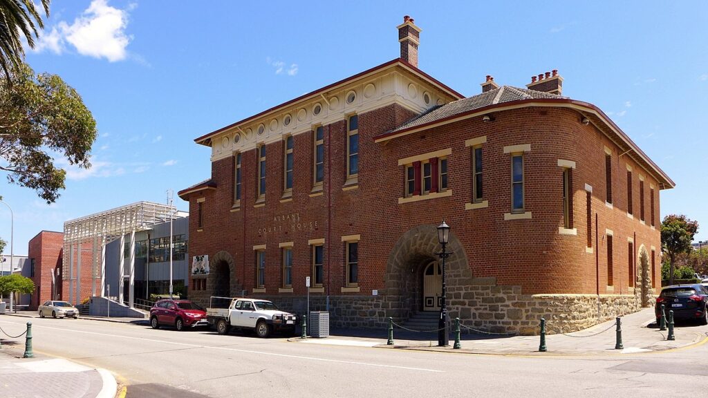
Built in 1896, the red-brick and granite Albany Courthouse, with its distinctive round front corners and convolute arched entryway, is still in use today. Nearby, the 1852 Old Gaol Museum was originally established for skilled convict labour from Britain but was expanded to be an all-purpose prison in 1873. Further expansions were made to imprison women and Aboriginals – it was seen as a more secure (ie: escape-proof) facility than the one in Lawley Park. Aboriginal prisoners were held in a separate timber cell – you can wander through cell blocks and see their cell carvings. The gaol was closed in 1941 and it reopened as a museum in 1996. Though not open to the public, the 1869, National Trust-listed Old Post Office has a 25m clock tower; it was originally also used as a customs house and a telegraph office in addition to being a post office and is now the Albany campus for the University of Western Australia and Curtin University.
For a great introduction to the town’s history, visit the Museum of the Great Southern, the Albany branch of the Western Australian Museum. Overlooking Princess Royal Harbour, it is anchored by a replica of the Brig Amity, which you board via a gangplank – informative volunteers detail what life was like for the crew, convicts and soldiers aboard the original ship some 200 years ago. Other permanent exhibits include a one-room period school – complete with holes for ink jars in the desks – and a gallery featuring stories of the Menang Noongar people, as well as a lighthouse exhibition and marine discovery centre, both in the Eclipse Building.
National ANZAC Centre
Telling the war through the stories of the ANZACs themselves, rather than through historical or documentary narrative, the centre – on Mount Clarence, providing a view of where the ships carrying the ANZACs departed – is a multi-award winner. You take the identity of one of 32 actual servicemen or servicewomen during the war, and follow their journey and experience – from recruitment and enlistment to theatre – through a variety of multimedia exhibits. At the end you find out if your person lived or not and, if they did, what happened to them post-conflict. A truly moving experience.
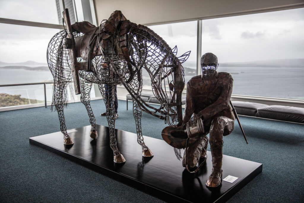
The centre is located inside the 1893 Princess Royal Fortress, also known as the Albany Forts. Complete with original gun emplacements, barracks and batteries, the fortress was built to protect trade coming into Australia’s eastern colonies – losing control of the sea lanes around WA’s southern coast was seen as a security risk by all the colonies, and so construction of the fort was financed by everyone, with the guns supplied by the British. The fort sits within the 250ha Albany Heritage Park, which includes the Desert Mountain Corps Memorial at the summit of Mt Clarence – a 1964 recast of the original 1932 statue at Suez, which was damaged and then brought to Australia.
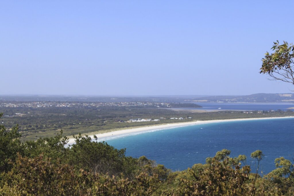
Middleton Beach
Stretching for 5km along Frenchman’s Bay, Albany’s town beach is a popular swimming, windsurfing and fishing spot, somewhat sheltered by two granite islands, Michaelmas and Breaksea. The Norfolk pines behind the sand have become iconic and a furor erupted in 2020 when the city removed a few for infrastructure reasons. An upgraded shark enclosure was installed in 2020, making the area safe for swimming. Another 4km north, Emu Point is the site of a narrow channel separating Oyster Harbour from King George Sound – the harbour side of the water is sheltered and very good for swimming. The views across the channel to Gull Rock National Park are grand, and there is a shop selling live blue crabs at the neighbouring marina.
Linking Middleton Beach with Brunswick Road, the 5km Ellen Cove Boardwalk around Ellen Cove provides stunning views out into King George Sound, as well as a whale-watching lookout (migrating humpback and southern right whales visit between May and November). About halfway along, there is also a life-size statue of Mustafa Kemal Ataturk, first President of Turkey in 1923–38, and commander of the forces that opposed the ANZAC troops at Gallipoli during World War I. He is carrying a speech he made to the first Australians and New Zealanders who visited the Gallipoli battlefield in 1934, laying down the foundation of a spirit of kinship between the Turks and the ANZACs even though they had been on opposite sides at Gallipoli.
Gull Rock National Park
Across Oyster Harbour from Emu Point, this highly scenic but somewhat underrated national park is great for swimming and views; the white sand tumbles down the green scrub-covered hills to the beach like a bag of spilled sugar. Beautiful Ledge Beach has a shipwreck that you can swim out to, while Nanarup Beach – technically not part of the national park, but on its eastern boundary – has a long, wide stretch of sand and a secluded cove.
Around Albany
Little Beach
Perched on Two Peoples Bay 40km east of Albany, this is one of the best beaches in all of Australia. If it was anywhere else in the world it would be sardine-packed with people, but it rarely is. The elevated car park gives you a great view of the curving white sands, complete with granite boulder, sandwiched between exquisitely blue water and green hills.
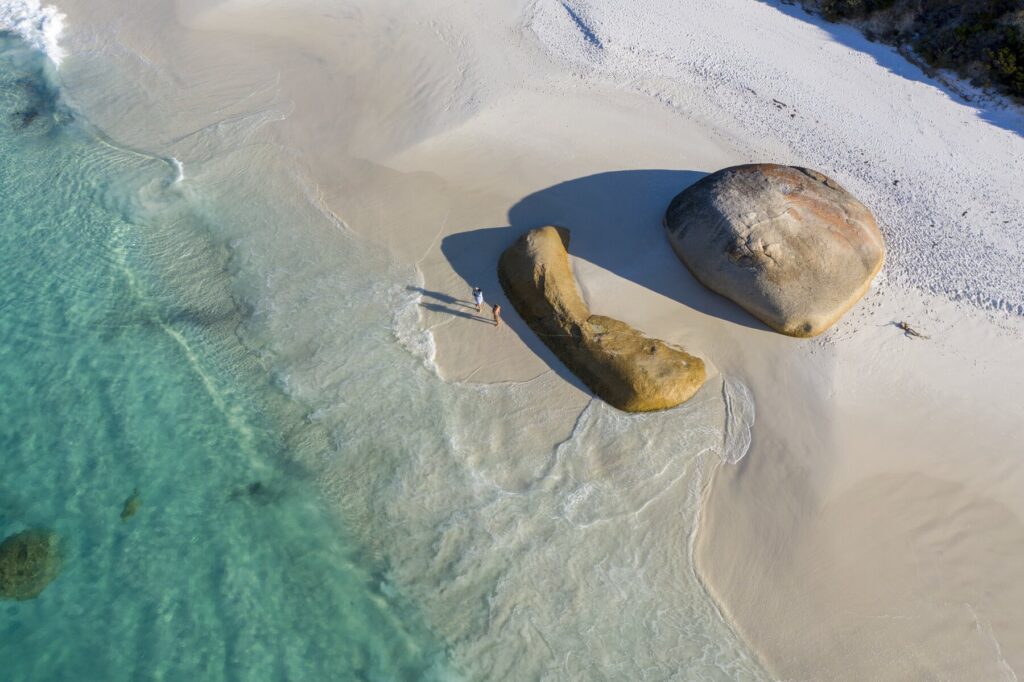
Climbing over these leads to a sheltered swimming area, and behind the granite rocks there is a walking trail to a boardwalk that has a natural wading pool. The highly endangered Gilbert’s potoroo was thought to be extinct for decades until it was rediscovered here in 1994; about 30cm long and weighing 10kg, it is arguably the world’s rarest marsupial.
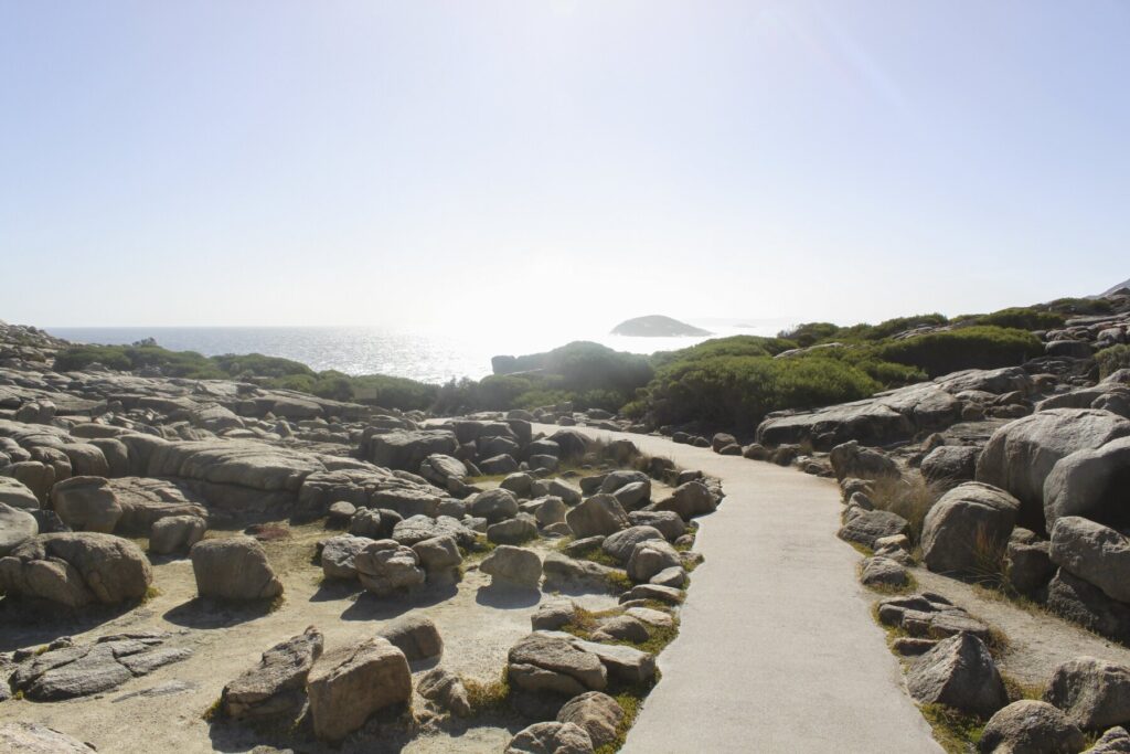
Torndirrup National Park
Made up of three interconnecting peninsulas – Flinders, Torndirrup and Vancouver – south of Albany, this 3,906ha national park is known for its dramatic granite coastal scenery. As you head into the park along Frenchman Bay Road, turn on to The Gap Road for one of the first landmarks – The Gap, a rectangular hole in the granite cliff-face that causes explosive wave crashes, sometimes upwards over 40m. A viewing platform, partially hanging over The Gap, was recently opened – despite being that high up, sometimes visitors do get splashed. A short walk away over the granite is Natural Bridge, a large natural granite arch that forms a gateway down the rocks into the water. Driving back towards Frenchman Bay Road, you can see Cable Beach, highlighted by a massive marble-shaped boulder weighing several tons that was thrown up on to the beach by the sea – a reminder of how powerful the ocean is.
Continuing south on Frenchman Bay Road, the next left turn leads to the Blowholes, where water gets pushed up through the cracks in the granite, creating a visual phenomenon similar to a whale spouting. The walk from the car park is 1.6km return. Further south is the superlative Jimmy Newells Harbour, an earplug-shaped blue and turquoise tiny, sheltered harbour, in between two densely brush-covered hills. The colour contrasts here are remarkable and it’s one of the most scenic parts of the park, although it’s visible only from a viewing platform. Frenchman Bay Road then curves north, from where a side road leads to Salmon Holes, a wild and rough beach famous for its dangerous rock fishing (people can and do die here – if you are going to rock fish, do not blow off the precautions), before finally the road ends between two beaches on Frenchman Bay.
Burrup Peninsula
Murujuga National Park is home to a natural rock art gallery with some of the world’s most ancient works, some 50,000 years old, and the Burrup Peninsula is a place that tries to find a balance between the economic importance of modern oil and gas exploration, with the cultural importance of historical preservation and environmental conservation.
Murujuga National Park
Covering the northern end of Burrup Peninsula, Murujuga National Park is one of the most spectacular and important Aboriginal rock art galleries in Western Australia. There are over a million drawings here, many dating back almost 50,000 years if not more, and the national park is in the process of being inscribed on the UNESCO World Heritage List.
If you have been to other rock art sites, Murujuga may seem a bit different. The drawings here are not in caves or on cliff tops – instead, the etchings are found on small red rocks that have been stacked in gigantic piles. Spotting the art is a bit like looking for orchids – it can be very difficult at first, but once you find your first one it gets easier and easier. One of the best drawings is one of a jellyfish with extra-long tentacles, though you will see plenty of creatures here including humans and unrecognisable animals that have probably been extinct for tens of thousands of years. Note that the open-air site lacks signage and railings, but this just adds to the mystique (though there is now a 700m boardwalk at Nganjarli). If you don’t fancy striking out on your own, various local operators run guided tours.
‘Murujuga’ means ‘hip bone sticking out’ in Yaburara. Almost all of the art here is in petroglyph form; Aboriginal peoples believe that the images were made by the Marga – creation spirits. While some of it is believed to be 50,000 or even 60,000 years old, varying sea levels around Australia and the presence of marine animals in many drawings, indicate that much of it would be much more recent – around the 6,000- to 8,000-year mark – as in different periods of Aboriginal habitation of Australia, this area would have been far inland.
North West Shelf Project Visitor Centre
Just south of the national park is the North West Shelf Project Visitor Centre, located within the Karratha Gas Plant. The Burrup Peninsula is home to massive natural gas exploration, and this centre has interactive displays and exhibits on the process of discovery, extraction and refinement. One-third of Australia’s oil and gas is produced here; it has generated A$35 billion in investment over its 35 years of operation and is Australia’s largest natural resource development project. Despite this, it is estimated that only about one-third of the shelf’s reserves have been exploited. The plant provides for much of the state’s domestic consumption; the pipeline from here to Bunbury is the longest in Australia (roughly 1,600km) and accounts for nearly all of the South West’s consumption.
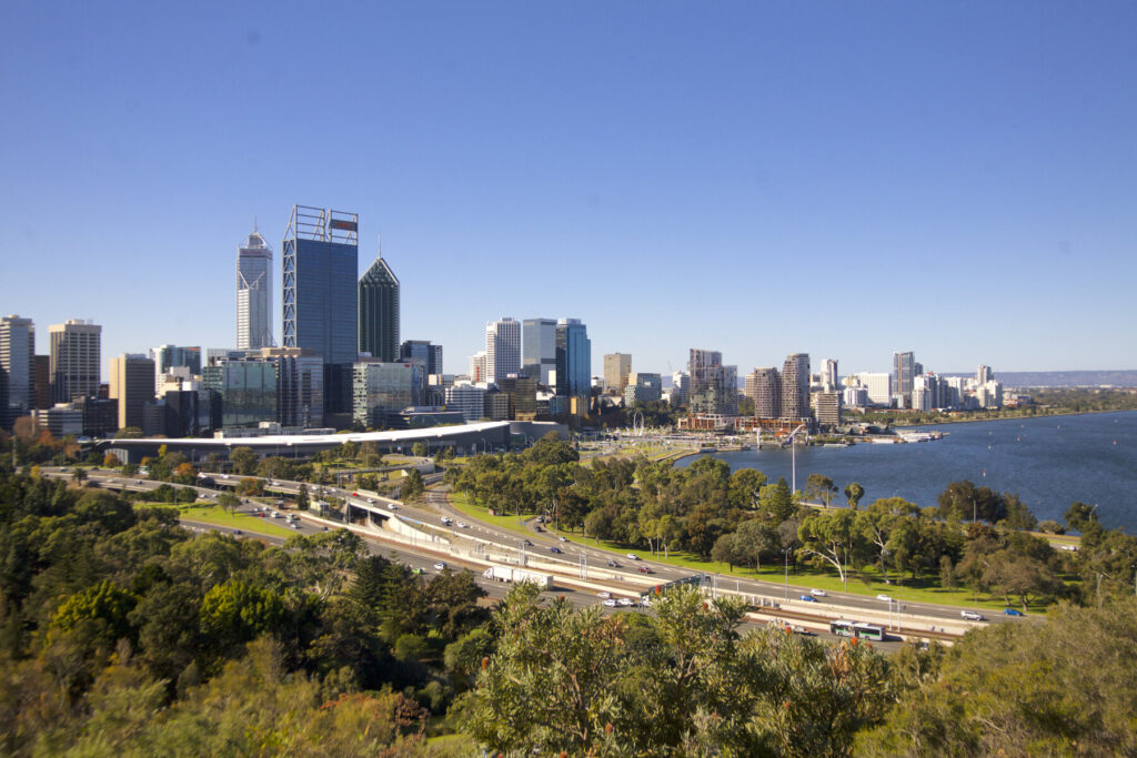
Central Perth
Perth’s central area does not feel as rushed or as hurried as CBDs or downtowns elsewhere, and why should it? The city’s signature attraction, the massive Kings Park botanical garden, is located here, as are the gentle flows of the Swan River, the eclectic café and dining culture of the Subiaco and Northbridge neighbourhoods, and the state’s iconic beach at Cottesloe.
The whole central region of the capital just begs you to slow down, take a stroll, do some window shopping, find a gourmet bite somewhere and then finish it off with a drink at a funky bar. The area sets the tone for the relaxed vibe that defines the metro area. A visit to Western Australia should start with two or three days here, acclimatising to the atmosphere, before branching out into Fremantle, the Swan Valley or the Perth Hills.
What to see and do in Perth
Kings Park
This huge 400ha botanical garden and nature reserve on the CBD’s western border is undoubtedly Perth’s signature attraction. Aside from being one of the world’s premier botanical gardens, it serves as a focal point for the entire Perth Metropolitan Area (and even the state) and is an integral part of the city’s identity.
Enter the park through the red-flowering gum-lined Fraser Avenue, which leads to the entrance of two of the park’s most-visited attractions – the Western Australian Botanic Garden and the State War Memorial. This is also where you’ll find the visitor centre (from where you can pick up a map), Aspects of Kings Park (the gift shop, from where guided tours leave), Frasers Restaurant and the Floral Clock, an operating timepiece on a huge bed of flora, originally designed in 1962. Strolling down Fraser Avenue is one of Perth’s great pastimes, with its lemon-scented eucalypts lining both sides; a memorial plaque sits at the foot of each tree, commemorating a prominent West Australian.
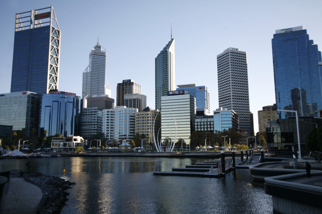
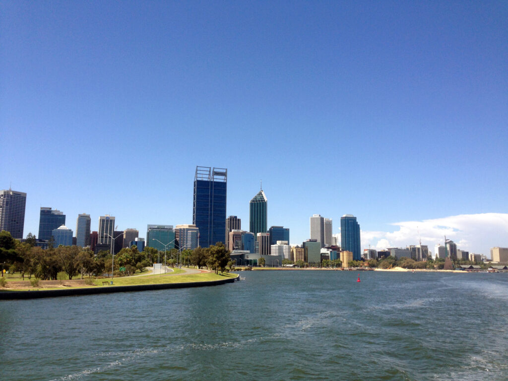
Just opposite the restaurant is the Kaarta Gar-up Lookout, from where the views over the Swan River and the city, as well as out to the Darling Scarp, are some of the best in WA – note two of Perth’s tallest skyscrapers, 234m-high Brookfield Place (with the BHP Billiton name on it) and 249m Central Park (emblazoned with Rio Tinto) just to the left. At sunrise or sunset, it’s a living postcard and a must-see on a Perth visit.
Fraser Avenue ends at the State War Memorial precinct, site of one of WA’s largest ANZAC Dawn Services (40,000 people annually), which frames another spectacular view over the water and to the city skyline. An 18m obelisk honours all West Australians who have lost their lives in the service of Australia; the Flame of Remembrance in the Pool of Reflection in the same precinct is always burning, and represents the promise of West Australians. There are various other war memorials dotted around the park, and the Memorials Walk has 12 points of interest, including the South African War Memorial for West Australians who died serving in the Boer War and the Aboriginal and Torres Strait Islander War Memorial near the Roe car park. There are also monuments to those lost at Kokoda, Gallipoli, Crimea, Waterloo, Jews who died in both world wars, and those killed in the Bali terrorist attack in 2002.
Encompassing some 17ha, the Western Australian Botanic Garden, opened in 1965, features a staggering 25% of all flora found in WA. Much of it is grouped by region, and there are Wheatbelt and Great Southern plantings, as well as areas for Rottnest, Mulga and other WA locations. The wildflower display here in late winter is spectacular and showcases the state in miniature. Aboriginal culture features prominently within the garden. The 3.2km Boodja Gnarning Walk explores bush tucker (food), traditional medicines, Noongar language and indigenous use of plants, while on the Lotterywest Federation Walkway is a giant boab tree, the Gija Jumulu, which is estimated to be 750 years old and was a gift from the Gija people in the Kimberley region.
The CBD
As you drive in on the Mitchell or the Kwinana, Perth’s CBD seems to rise up out of nowhere; a small cluster of gleaming skyscrapers that would not be out of place in Dubai or Tokyo. But Perth is not a dense urban jungle of high-rises; they are concentrated in the fairly compact and highly walkable CBD, providing a stark visible contrast to the rest of the city.
The CBD forms a rectangle, with the Swan River forming its southern and eastern boundaries, Kings Park its western boundary and Wellington Street its northern boundary. Inside, ample one-way streets, pedestrian malls and a plethora of cafés and restaurants invite leisurely exploration – a big city without all the big city hassle. Even parking isn’t a problem (well, not that big a problem anyway) – large ticketed garages are easy to find across the CBD.
Cathedral Square
Perth was founded here in 1829, and this spot remains one of the CBD’s focal points with its cathedral, town hall and old government buildings. Old and new contrast sharply here – with the hulking, modernist City of Perth’s administration building now across the street.
Its most striking figure is the imposing St George’s Anglican Cathedral, a Gothic Revival church built in 1888 with handmade bricks. The showpiece of the Anglican Church in WA, it remains one of the most important religious institutions in the state – its brick interior arches and walls, chandeliers and deeply sloped roof give it an understated elegance. The grounds have memorials to important West Australians and soldiers, and a Soldiers’ Chapel that honours Anglican soldiers who fought for Australia in World War I. The cathedral’s choir is nationally acclaimed and there are often lunchtime concerts; see website for dates.
Opposite the cathedral are the State Buildings. Western Australia’s government centre since the 1870s, the site has seemingly hosted every government agency at one time or another, from immigration to treasury to the police court to the premier’s office. Its final tenant was the Department of Land Administration, which left in 1993. Redevelopment some years later saw it begin to regain its former glory as an entertainment centre and today it is steeped in historical elegance with dozens of boutiques, dining options and a luxurious hotel.
Barrack Square and Elizabeth Quay
On the banks of the Swan, 400m south of Cathedral Square, Elizabeth Quay is the brainchild of former premier Colin Barnett – who said he decided the need for riverfront redevelopment after walking Brisbane’s South Bank with his wife in 2009, making him realise Perth’s vibrancy had fallen significantly behind not just Asian cities but Australian ones too.
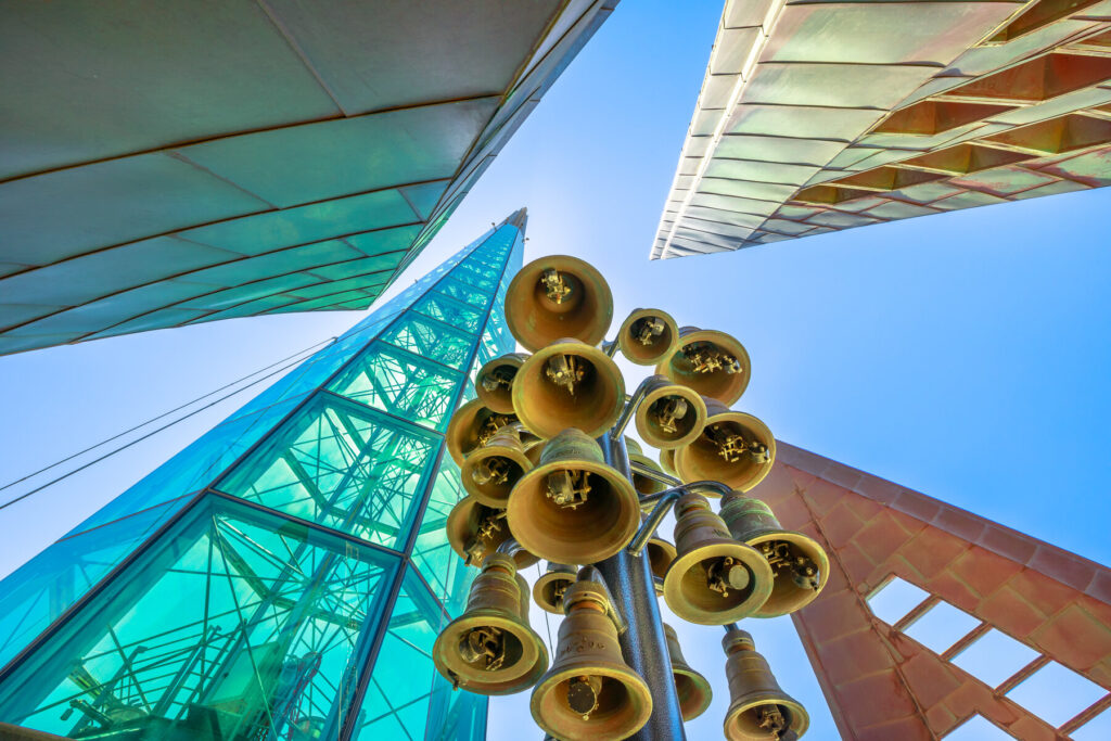
The area is dominated by the pointy, 82.5m tall Bell Tower, home to the 18 Swan Bells, a dozen of which came from St-Martin-in-the-Fields Church, Buckingham Palace’s parish church in London. The bells rang in Trafalgar Square for centuries before being donated to WA for the nation’s bicentenary celebrations in 1988. The bells ring Monday, Thursday and Sunday for an hour from noon, and there are interactive exhibits inside on how to ring the bells. If you think that bell ringing is just about standing around pulling ropes, a visit here will change your perception.
On the other side of Riverside Drive from the square are the well-manicured Supreme Court Gardens and Stirling Gardens, Perth’s oldest gardens, a landscape classified by the National Trust and originally used in the 1830s to help cultivate plants from seeds. Both gardens surround Perth’s oldest building – the Supreme Court of Western Australia, dating from 1836. Today this houses the Old Court House Law Museum, one of the world’s only law museums, home to over 2,000 artefacts that document the legal history of WA dating back to colonial times.
Art Gallery of Western Australia (AGWA)
Housed in the Perth Cultural Centre, the 18,000+ works here – the first one purchased in 1895, including paintings, sculptures and indigenous works – are the state’s premier collection. The gallery is diverse, with art from Aboriginal and Torres Strait Islander peoples, 20th-century Australian and British artists as well as those from the state. In late 2021, it launched ‘The View From Here’, the gallery’s largest-ever showcase of West Australian art, involving 230 artists and 361 works. The rooftop has also been converted as a part of this, framed by the Perth skyline, with an open-air sculpture walk.
WA Museum Boola Bardip
Originally established in 1891 at the old Perth gaol, the name of this museum means ‘many stories’ in the Noongar language – appropriate for an institution that views itself as a centre for the exchange and communication of WA’s stories. The connection between people and place is a special emphasis of this museum, and this permeates through all its exhibits, transforming the space from a dull display of objects into a vibrant showcase of Western Australia, its people, stories and land, in all entirety.
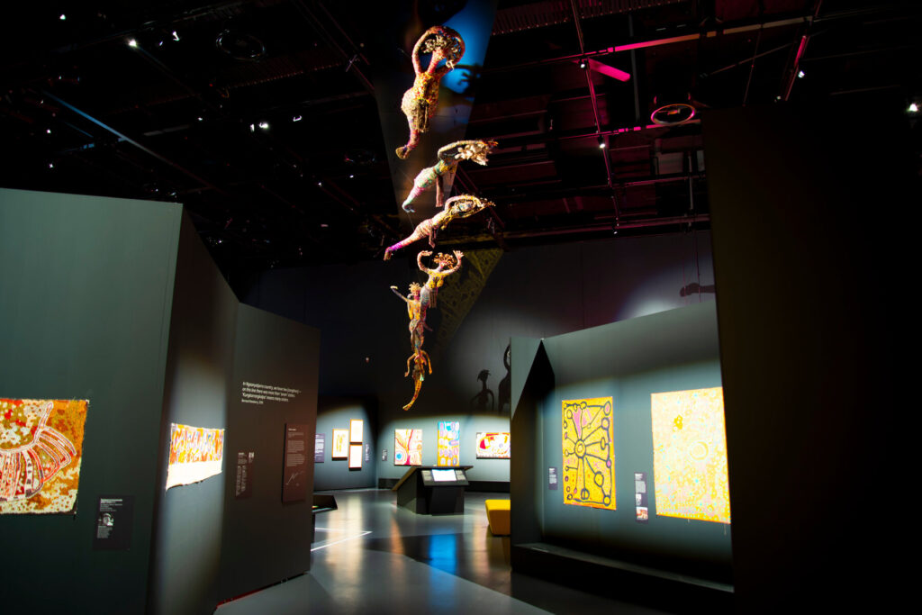
The museum is organised around three themes: ‘Being West Australian’, geared towards showcasing the state’s diversity; ‘Discovering Western Australia’, offering visitors a gateway to the wonders of the state; and ‘Exploring the World (Western Australia’s place in it)’, which aims to define the state and its contrasts and niche in the global community. Permanent exhibitions include ‘Reflections’, which explores perspectives of different West Australians that make the state what it is – from those descendent from millennia-old Aboriginal cultures to new migrants – while ‘Changes’ looks at how humans have changed the environment to suit their needs – from Aboriginal land management to contemporary financial uses like mining.
Perth Zoo
Just across the river from Kings Park and the CBD in South Perth, this 125-year-old zoo houses both local favourites like bilbies, black cockatoos, potoroos, tree kangaroos and gliders and far-away exotics like lions, lemurs and penguins. You can get to the zoo by ferry from the CBD – the entrance is 500m from the Mends St Jetty.
Subiaco
Known as ‘Subi’, this Perth suburb 5km west of the CBD is known for its upscale, hip bars and cafés, preserved architecture and stately homes. When the Perth to Fremantle railway was constructed in the 1880s, a station was built in Subiaco that ignited an economic boom and an influx of settlers, business and industry. Many of the houses built during that period survived and are still in use today – 791 buildings in Subiaco are Heritage-listed.
In particular, Subiaco houses are known for their leadlights – coloured, decorative and elaborate windows with glass separated by lead and metal bars. They are similar to stained glass, though leadlights are more associated with commercial enterprises and housing, and have a more simplistic design than the stained glass found in churches. Subiaco’s Leadlight Night – usually in December – has free walking tours where residents are encouraged to leave their hallway lights on, making their door and window leadlights highly visible to the public. Ask the visitor centre for details. The city also offers a self-guided Leadlight Tour on its website that starts and ends at the Subiaco Museum.
The Swan River
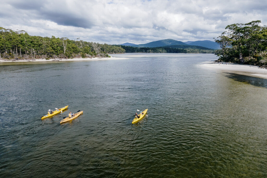
At 72km long and 21m at its deepest point at Mosman Bay, WA’s best-known river forms an integral part of the state’s identity and was the lifeblood of the colony’s original European settlements. It’s also a focal point of Perth’s outdoor activities, with miles of footpaths for walking, jogging and biking, and the waters teem with boaters, kayakers and swimmers. Swans on the Swan hires out everything from pedal boats and SUPs (A$55/hr) to kayaks (A$35/hr), but if you need some guidance then Water Wanderers offer kayak tours (from A$75pp) led by Leonie, who was long-term president of the Ascot Kayak Club and a veteran of kayaking expeditions in North America.
Located in the river between East Perth and Victoria Park and connected by a causeway is Heirisson Island, a nature reserve with a 2km walking trail, great birdwatching (look out for great egrets, ospreys and Australian ibis) and a kangaroo sanctuary. There is also a statue to Yagan, the Noongar leader during the Swan River Colony days.
Cottesloe Beach
Some 15km from the city centre is the epicentre of Perth’s beach culture, Cottesloe Beach, which has been a see-and-be-seen place for over a century. With both reefs and waves, it’s a great spot for surfers, snorkellers and beach cricketers, and the blue and green waters backed by the dense Norfolk pines behind make for a truly wonderful setting – though the beach was the site of one of WA’s most notorious shark attacks, when in 2000 local resident Ken Crew was killed by a Great White.
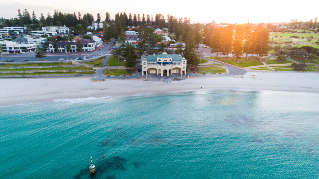
The star of the show here is the Cottesloe Beach Pavilion, sometimes called the Indiana after the Indiana Teahouse – originally constructed in the 1920s, it was demolished and replaced by another pavilion in 1983. This was deemed too small, however, and another new building (though designed to look traditional) was erected on the original foundations. Public interest in the teahouse remained muted until Taylor Swift visited in 2012 and shared on social media how much she loved the building. Now – partly due to publicity, and partly because it really is a lovely building in a popular spot – it is arguably Perth’s most recognisable building with its wide arches, semicircular windows recalling an image of the sun and green dome roof.
Theatre and arts
Theatre goers should try and catch a show at His Majesty’s Theatre. When it opened on Christmas Eve 1904, it was the largest theatre of its kind in Australia. Today, shows range from black comedies like Hell Hath No Fury to Neil Diamond tribute acts. Guided tours of the facility are also on offer; check the website for times and prices. There are numerous theatre companies in Perth, one of the most notable being the Black Swan State Theatre Company who put on many original performances at a range of venues.
Perth Concert Hall is the main venue of the West Australian Symphony Orchestra and also hosts musicals and other performances such as the West Australian Opera.
Esperance
Esperance has a spectacular coastal setting and has taken full advantage of it. The seafront promenade in the CBD, lined with the town’s famous pines, has a beautiful vista out to the massive granite outcrops in the Bay of Isles. To the west of the CBD, the 40km circular Great Ocean Drive is one of the best coastal roads in Australia, passing postcard-worthy beach after beach after beach, while the national parks to the east of town present even more squeaky, sugar-white sands framed by golden-brown outcrops – most of which you are likely to have all to yourself.
What to see and do in Esperance
Cape Le Grand National Park
At 318km², this sweeping heathland is dotted with light brown granite outcrops and white sandy-beach coves. Jewel of a thousand brochure covers, Lucky Bay with its impossibly clear water, crystal-white sand and spectacular, sheltered granite backdrop – is unsurprisingly the centrepiece of the national park. It’s undeniably popular with visitors but don’t worry – even when the beach is ‘packed’, this is only by Outback standards and you will find plenty of space on the sand for yourself. The swimming here is magnificent – the clarity of the water is such that it feels like you’re in a swimming pool. There are also heaps of marsupials – while the kangaroos get the attention here, the park is also home to honey and ring-tailed possums and bandicoots.
For the experienced walker, the 17km (one-way) Coastal Track goes from Le Grand Beach to Rossiter Bay, taking in Lucky Bay, Thistle Cove and Hellfire Bay (another popular swimming beach) and providing beautiful headland, coastal and ocean views along the way. Though different sections of the walk have different class ratings, it is a challenging walk; be prepared for Class 4 and Class 5 conditions. All of these beaches can be visited by car.
Away from the coast, the national park is dominated by dramatic granite hills, the best-known of which (though not the highest) is Frenchman Peak (262m). There is a Class 4, 3km return hike to the summit that provides great views of the park. Mount Le Grand, near Hellfire Bay, is the highest peak in the park at 345m; however, access is difficult and there are no marked trails to the summit.
Whale Tail Sculpture
The town’s famous pines curve around the footpath along Esperance Bay, creating a foreshore that links the bay to the town and provides beach access in front of the CBD. One of the most prominent sights here is the Whale Tail Sculpture, created by local artists Cindy Poole and (British-born but now Esperance-local) Jason Wooldridge as part of the foreshore redevelopment project in 2014 – the sculpture represents the southern right whale population in the offshore waters. Though the town beach can be accessed anywhere along the foreshore, the main swimming areas are in the suburb of Castletown, north of the CBD, along Castletown Quays Road and at Bandy Creek (take Goldfields Road to Daw Drice), which is also a boat harbour and popular fishing spot.
Esperance Museum
A good place to learn about Esperance’s history is the Esperance Museum, a vast warehouse brimming with some 4,000 objects – including a 19th-century train carriage that you can climb aboard. There is also a model of Skylab, the NASA space station that crashed near here in 1979, with actual debris (including the oxygen tank) from the wreck.
Nearby is the Historic Museum Village, a collection of restored old buildings (including a school, courthouse and chemist) dating from the late 1800s, which have been repurposed into shops and galleries; it is easy to imagine yourself in the period as you wander through here – though it’s worth noting that the buildings were moved here from other parts of Esperance and this is not an intact historical quarter in its original location. The Museum Village Markets are held here (usually) on alternating Sundays.
Great Ocean Drive
Starting from the town centre, this 40km circular route west of town is one of the best scenic drives in the state. Starting on Twilight Beach Road at Esperance’s southern boundary, the road quickly sweeps westward along the coastline. The views start almost immediately, as you drop down from the first hill towards West Beach, when a vista of the Southern Ocean unfolds in front of you. This is the first beach you get to on the drive, 3km from the CBD, and how glorious it is – a sweeping white bay with a reef in front of it and a big granite hill forming a massive natural wall on the eastern side. You can swim here, carefully – note the signs about rips.
Blue Haven Beach is next, about 4km beyond, and is one of the most popular swimming beaches – with calm conditions close to the shore and a stunning outlook to Chapman Point and West Beach in the distance. Long-distance views and more beaches then follow for about 5km until you reach Esperance’s star, Twilight Beach, roughly 12km from town and routinely voted one of the best beaches in Australia. While it has the pre-requisite vanilla sands and impeccably turquoise waters, what sets it apart are the unusually shaped outcrops just offshore – one with a massive circular dent in it about two-thirds of the way up – that, when photographed with the seagrasses behind the beach, offer a truly photogenic scene. Though the postcard-worthy landscapes continue after Twilight Beach, both Ten Mile Lagoon and Eleven Mile Beach are very attractive with sand dunes in the background and a reef bar in the foreground – though the water here can be too shallow for swimming.
Lake Warden Nature Reserve
Recognised as a Ramsar Site of International Importance, this wetland complex is made up of a series of lakes on the north edge of town and can support nearly 30,000 waterbirds including hooded plovers, grey and chestnut teals and black swans; it is also important as a site of refuge for birds impacted by drought. The Kepwari Walk, which starts/ends at the Lake Wheatfield car park, is a great place to spot birds with hides en route. Birds Australia’s Birdwatching Around Esperance brochure (pick it up at the visitor centre) is an excellent resource describing the variety of birds you are likely to encounter.
You can also canoe or kayak here, but you need to bring your own. The 5.5km Esperance Lakes Canoe Trail starts at the Lake Wheatfield car park and has markers every 200m to guide you – though you have to do this trail in winter when the water levels are high enough. There are also launches at Woody Lake and Lake Windabout.
The Recherche Archipelago
Also known as the Bay of Islands, this group of 105 granite islands is located just a few kilometres off Esperance’s coast. The only inhabited island is Woody Island, where there is a visitor centre, café and accommodation; Woody Island Eco Tours runs ferries and tours to the island. There is decent snorkelling, swimming and walking trails – if you want to get out on to the water and clamber about the granite islands, this is an easy option; day tours leave from the Taylor St Jetty.
The largest in the archipelago, Middle Island, near Cape Arid, is home to the bright-pink Lake Hillier its size, nearly 15ha, differentiates it from some of the state’s other pink lakes in places like the Wheatbelt, and the contrast of its white salty shores, the turquoise waters of the surrounding ocean and the green vegetation on the island make it as photogenic in real life as it is in the brochures. Scientists aren’t really sure what makes Lake Hillier pink – generally it’s believed to be related to salinity, but Lake Hillier is different from WA’s other pink lakes because it stays a vibrant colour all year round rather than fading with the seasons.
Stokes National Park
Known for its 14km² inlet, this 10,667ha national park 80km west of Esperance is a fishing haven where long beaches are fringed by dense bushland (although you will need a 4×4 to make the most of them). Terrific snorkelling can be enjoyed at Shoal Cape, while further west Skippy Rock is great for diving, snorkelling, swimming and fishing – both have small, basic DPaW camping facilities.
Abundant birdlife frequent the inlet’s waters – black-browed albatross, white-naped honeyeater and fairy tern are just a few of the 40 species found here – and there is a boat launch at the end of Stokes Inlet Road from which canoeing and kayaking are also popular. Also in the park are the 1870s’ ruins of Moir Homestead, home of the Moir family who were early pastoralists – the homestead is on the Heritage Register as an example of early pastoral structures in the area. Note it can only be accessed by 4×4 on the way to Shoal Cape.
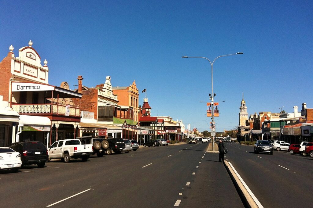
Kalgoorlie-Boulder
Kalgoorlie has a reputation among West Australians as an anachronism, a time-capsule frontier town where mining is king, lady luck is queen, the law is somewhat hazy and anything goes. But beneath the rough-and-tumble veneer of WA’s largest Outback town lies an understated cosmopolitan vibe, apparent through its dynamic embrace of flamboyant architecture, fine galleries and some excellent restaurants – all that mining money has to be spent somewhere!
The City of Kalgoorlie-Boulder formed from the merging of the twin cities of Kalgoorlie and Boulder into one unified local government area in 1989 (locally referred to as just Kalgoorlie). The two towns are one seamless area and it is indistinguishable where Kalgoorlie ends and Boulder begins. Together, they form the fifth-biggest centre in WA with a population of about 30,000.
Gold sights
The Kalgoorlie Heart of Gold Discovery Tour is a great starting point to the ‘Golden Mile’ and understanding Kalgoorlie’s history. Available as an app, this self-guided walking tour (2km; about 1hr) takes you around 11 sites in the Kalgoorlie CBD (all but three are on Hannan Street), starting with the gold bar replica at the Market Arcade and finishing at the Museum of the Goldfields.
Super Pit & Lookout
Kalgoorlie’s signature attraction is recognised country-wide. This is one of the biggest mines in Australia – almost 28,350kg of gold are mined out of the 500m-deep pit annually. The viewing platform is on Outram Street, just off the Goldfields Highway, and staring down into this neatly terraced abyss and seeing its haulage vehicles – gargantuan up close, but which look like insects in the Super Pit’s massive expanse – is an unforgettable experience. You can also check mine operator KCGM’s website for when blast times are and view a blast (a detonation to break apart rock, making it easier to remove) from the lookout.
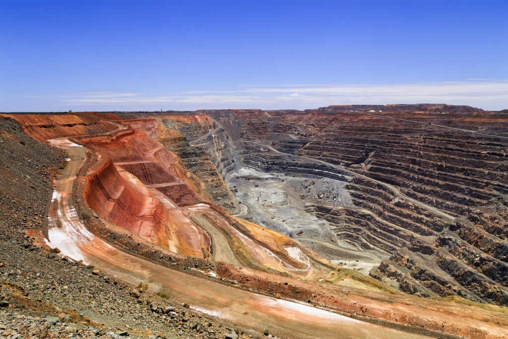
The Super Pit is one attraction where it pays to invest a bit more and book a guided tour to see the workings inside the pit itself. Kalgoorlie Tours & Charters is recommended and authorised by KCGM; they offer 1½- and 2½-hour tours that travel on the same access roads as the dump trucks, show you the old mine shafts and offer excellent vantage points of modern mining machinery and operations. As this is a working gold mine, there are safety requirements in place to be able to take the tour, including wearing appropriate clothing.
Hannans North Tourist Mine
Originally one of the first mines in the Goldfields in 1893, this is no longer a working mine like the Super Pit but instead a must-see interactive tourist experience, enjoyable for both adults and kids. Visitors can mine their own gold, clamber aboard a haul truck and even visit the underground refuge chamber, designed to keep miners alive in the event of disaster. Period buildings have also been relocated here and there is a set-up where you can experience life at an 1890s prospector’s campsite. Gold-pour demonstrations usually occur during school holidays – call to verify times.
Museum of the Goldfields
The Kalgoorlie branch of the Western Australia Museum, this is a good place to learn about the region’s mining history. Home to the state’s largest collection of gold bars and nuggets, it also chronicles how Kalgoorlie’s Outback geography – often the first stop for travellers coming west – has impacted the state’s development. Permanent exhibitions include a relocated miner’s cottage, opulent period-era mining office boardrooms and a Heritage-listed hotel that has been remodeled to contain exhibits and galleries. The main gallery traces the Gold Rush’s influence on the area. The Gold Vault has a display of nuggets and holds half of the state’s gold collection.
Kalgoorlie
Hannan Street
A great walk to do in conjunction with Heart of Gold Discovery Tour, the Heartwalkis a collection of over 60 public art murals by local artists. Jason Dimer’s Kgungka Thurtu (Sister Girl) dot painting, in honour of his deceased younger sister, is a personal favourite, as is Brenton See’s Freedom in Red, an ode to the spectacular flora and fauna of the Goldfields bush. A map (and kids’ activity sheets) can be downloaded from the website, and many of the murals are along Hannan Street.
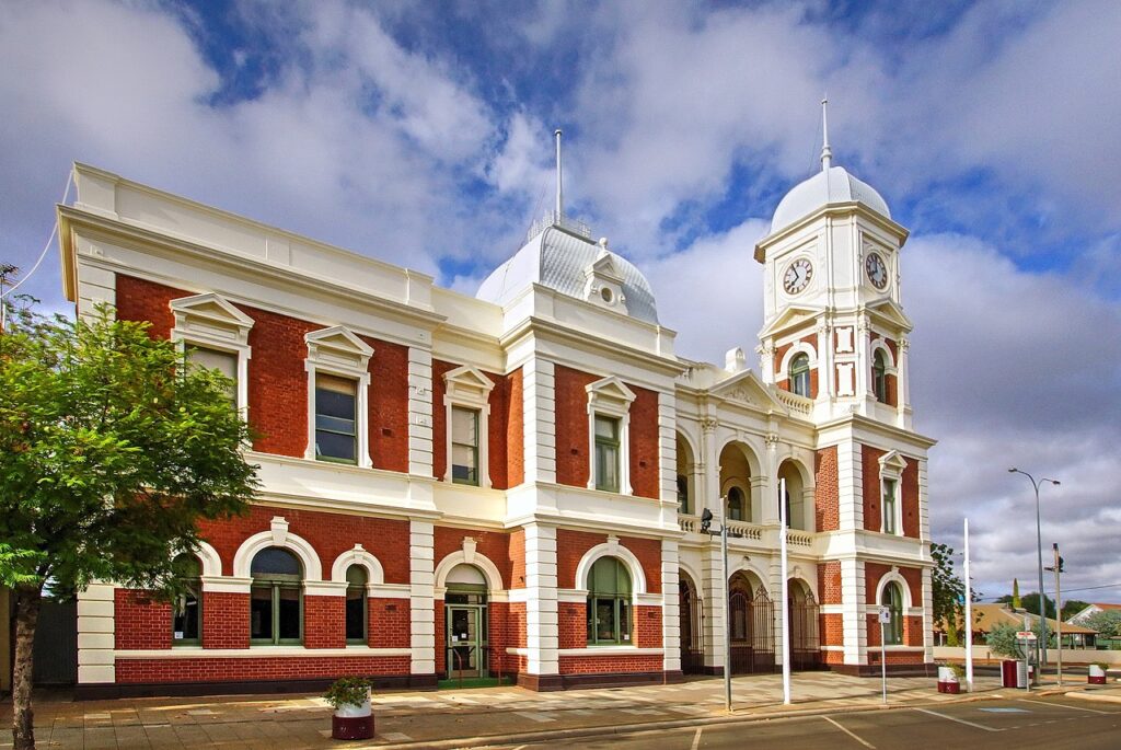
Elsewhere on Hannan Street is the Government Precinct, a Heritage-listed complex of buildings all designed by the same architect, J H Grainger, and consisting of the Old Post Office, Warden’s Court, Mines Department and Courthouse. In 2013, they were amalgamated and restored into a contemporary new courthouse, at a cost of nearly A$42 million. One of the notable features of this precinct is the stately and still-functioning clock tower, built from soft pink stone and topped with a gold dome. Unfortunately, views are only from the outside looking up – it is not open to the public.
Kalgoorlie Town Hall
Continuing south along Hannan Street, you’ll reach Kalgoorlie Town Hall. Though a notch below that in Boulder, it is still a very impressive sight – the powder-pink edifice of this Heritage-listed building is one of Hannan Street’s most beloved local landmarks. Built as a catch-all in 1908 with theatre, council chambers and municipal offices, the upstairs foyer now hosts a local Sporting Hall of Fame. The inside foyer also has a commemorative statue of prospector Paddy Hannan.
Signpost Goldfields Racing Museum
On the grounds of the Kalgoorlie-Boulder Racing Club, this museum showcases many exhibits from horse racing including a restored hansom cab, old ‘photo finish’ equipment used by judges, and Melbourne Cup memorabilia. The club’s website includes information about the track and a calendar of upcoming races.
Hammond Park
Just 2km north of the CBD, this park offers a peaceful retreat from the city nestled in the middle of the Outback. The ponds attract a number of local birds and you’ll also spot peacocks roaming around. The grounds feature a miniature Bavarian Castle, and also a children’s playground. Adjacent to the park is the dog-friendly Kalgoorlie Arboretum, set on 26ha of native bush representative of the Great Western Woodlands and featuring bushwalks through the eucalyptus; there’s also a picnic area and small dam that attracts birds like red wattlebirds and mistletoe birds.
Boulder
Boulder Town Hall
The main reason to visit this part of town is to admire the magnificent, Heritage-listed Boulder Town Hall. Built in 1908, this Federation Free Classical-style building captures the spirit of the turn-of-the-century Goldfields and is truly eye-catching, with its white clock tower and verandas contrasting against the red bricks. Inside, cast-iron pillars support an elevated horseshoe-shaped seating veranda with ornate balustrade. Over the decades the hall has hosted numerous musical performances, including Victorian opera singer Dame Nellie Melba.
Inside the theatre is the Goatcher Curtain, considered a priceless work of art – one of the last working stage curtains in the country, it was painted by Philip Goatcher with a depiction of the Bay of Naples and Mount Vesuvius. It gets lowered on Tuesdays, Wednesdays, Thursdays and Boulder Market Days. The Town Hall also contains the Local History Archive and the Goldfields War Museum which covers the involvement of local residents in wars from the Boer War to the 21st century, though artefacts, documents and images.
Karijini National Park
Karijini National Park, with its dramatic gorges, world-class plunge pools and colourful terrain, is one of Australia’s finest national parks – if not the world. A trip here is a highlight of any visit to WA and it’s the sort of place that ends up being a lifetime highlight as well. Be warned, it is a trek to get here – you don’t just add it on to the itinerary as a side trip – but all the park’s major attractions are accessible in a 2WD. If you have a chance to come here, take it.
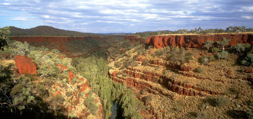
If your idea of the Outback is a dusty, dry desert, Karijini’s rugged terrain and red mountains will change that instantly. The Hamersley Range runs through the park, boasting both WA’s tallest mountain, Mount Meharry (1,249m), and the second-tallest, Mount Bruce (1,234m). The contrast of the bright-red mountains and almost neon- green hills, covered with spinifex and shrubbery, is awe-inspiring. At 627,422ha, the park is WA’s second largest (after Karlamilyi), and there are plenty of escarpments, plateaux and gorges for hiking, plus some spectacular plunge pools that could go up against the world’s best.
Eastern side
Dales Gorge
West to east, the major sites here are Fern Pool, Fortescue Falls, Three Ways Lookout and Circular Pool. There are car parks at Fortescue Falls and Circular Pool, and Dales Gorge has a campground. Hiking trails link or pass all four sites; a combination Class 2 and Class 3 hike on the edge of the gorge, or a Class 4 hike into the gorge itself.
From Fortescue Falls car park, it is about a 1.2km (Class 3/4) hike down into the gorge to the spectacular freshwater Fern Pool. It’s a fantastic place for swimming – there’s a waterfall pouring down from a long shelving ledge, and greenery around the other three sides. You can also go up under and behind the waterfall for a unique viewpoint. If you enter the water, please do so quietly and respect the land’s Traditional Owners. The Creation Serpent is said to live here – having arrived after travelling through the Pilbara landscape, its movements creating the waterways. En route to Fern Pool you’ll pass Fortescue Falls – another glorious swimming spot, highlighted by a long waterfall that slides its way down red rockface; the stepped appearance of the rock to the right of the falls adds drama to the scene. From here, there’s an optional 800m (Class 3) detour to Fortescue Falls Viewpoint, where a viewing platform gives a beautiful aerial vantage point of the falls.
Kalamina Gorge
Given its location, on a 4×4-only track off Banjima Road, Kalamina is not one of Karijini’s ‘headline’ gorges – but the crowds are often thinner, making it a good option if you are looking to break away from the pack. Though not as deep as others, the gorge is still accessed by a Class 4, 3km return trail which leads down to the permanent pool, with a seasonal waterfall – Kalamina Falls. Walking along the gorge floor is not as demanding as the other hikes; you will pass rockpools and some colourful rock walls, until you reach the end point at Rock Arch Pool.
Western side
Weano Gorge
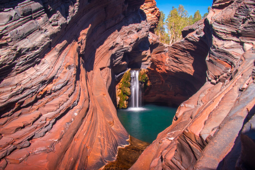
Weano Gorge is often downplayed, but for our money Handrail Pool – your reward at the end of the Lower Weano Gorge hike – is one of the most spectacular plunge pools in the country, if not the world. If you are able to negotiate the Class 5, 1km walk – do so. It starts off easy, but don’t be fooled – there are steep, slick descents, narrow passageways and, at times, you have to walk through water – an elderly man slipped and died here in April 2021. As grumpy as you may feel on the difficult and slow trek down, all is forgotten once you get your first glimpse of Handrail Pool – so named because of the handrail you grip as you descend. The deep, steep, red, orange and pink rockface walls contrast with the brilliantly coloured water, occasionally making a green-tinted border where the two meet. The water’s small waves reflect off the walls of the gorge, and there is an echo when you speak.
Hancock Gorge
Accessed from the same car park as Weano Gorge, Hancock Gorge is home to the immensely challenging Spider Walk – so named because to get through the passageway, you have to stick your legs and arms out to the sides of the narrow chasm like a spider. There are rock steps, uneven ground and you will have to negotiate through water. Kermit’s Pool, the end point, is beautiful but can feel narrow, and the colours darker than the other pools, surrounded by steep walls.
Joffre Gorge
The Class 5,3 km walk through Joffre Gorge leads to the incredible Joffre Falls – almost perfectly centred at the end of a narrow gorge, as if it knows it’s the showpiece. The falls seem to curve towards the bottom like someone slouching into their chair. When you’re at the bottom of the gorge, your vantage point can make it seem like you’re standing at the bottom of a giant tin can. If you don’t want to do the hike, there is a lookout just 100m from the car park.
Northern side
Hamersley Gorge
Disconnected from the other popular gorges in the park, Hamersley Gorge – in the northwest, and accessed on a different road – is a somewhat gentler gorge than its cousins. The rock here has some distinctive geology behind it and looks almost diagonally patterned in parts down the long face to the water.
There are some waterfalls here, plus a fabulous swimming plunge pool, and the gorge is significantly wider – which gives broader views and permits a less claustrophobic feeling. The walk down is also a bit more relaxed – a Class 3, 400m hike that almost feels like a stroll compared to some of the other gorges.
The ‘Four Mountains’
Though the Stirling Range in the Great Southern gets all the attention, WA’s tallest mountains are actually in the Pilbara, close to Karijini’s gorges. The state’s second-highest peak at 1,234m, Mount Bruce is very accessible from Karijini Road, near the western entrance to the park. There are three walks here, the shortest of which is the Marandoo View Walk (Class 2; 500m), with views out over the mine site. The Honey Hakea Walk (Class 3; 4.6km) has good vistas of the surrounding mountains and scrub, while the Summit Walk (Class 5; 9km) takes you to the top with even grander panoramas of the craggy Pilbara mosaic. The views into Karijini and out to the Marandoo mine site make this a great spot for contemplation and reflection about the yin and yang of the economic use of the land that powers the state’s economy and the livelihood of its residents, in stark contrast against the geographic beauty and cultural value of this landscape. If you can’t get to Millstream-Chichester, it is worth doing this one for the views.
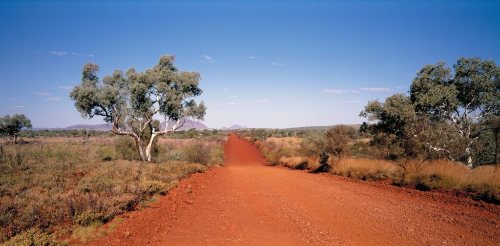
Mount Meharry (1,249m) pips Mount Bruce as tallest mountain by only 15m, but it is considerably more challenging to reach this peak. You can drive to the summit along a difficult 4×4 track – accessed from Juna Downs and the Great Northern Highway – but call the visitor centre ahead of time for conditions and information.
There are two other peaks that are good for climbing – Mount Nameless and Mt Sheila, both outside Karijini near Tom Price. Mount Nameless (1,128m), also known as Jarndunmunha, looks over the town like a sentinel, its shape somewhat similar to a right triangle; you can drive to the summit in a 4×4, or hike up (Class 4; 4.5km) starting from the speedway. The summit affords views of the town and mine site. Smaller Mount Sheila (987m) is north of Tom Price – again 4×4 only – and about 40km west of Hamersley Gorge – access is via the private Tom Price Railway Road, so you will need to get a permit first from the Tom Price Visitor Centre.
Ningaloo Reef
Although its big brother, 70km off North Queensland, gets all the attention, the Ningaloo Reef is in many people’s eyes even better than the Great Barrier. It is certainly one of Australia’s most underrated gems – its isolation, located in one of the country’s least-populated areas, has protected it from overdevelopment and crushing tourist hoards. While the Great Barrier is bigger, Ningaloo is a lot more accessible – as a fringing reef, rather than a barrier reef, it extends much closer to the shoreline and in many places you just walk into the water off the beach and you’re there.
The largest reef in the world near a land mass, at 300km long, it became UNESCO-listed in 2011 because of its incredible biodiversity – it is home to over 200 species of coral and 500 animal species; it is on the migratory routes of dolphins, whales, dugongs and rays; and is an important nesting site for turtles. The area is most famed, however, for its gentle whale sharks – the biggest fish in the ocean (it can reach over 20m in length and over 40 tonnes in weight) with a mouth over 1m long. Best seen between March and August, their distinctive polka-dot pattern – white spots on grey skin – is unique to the individual, in the same way no two snowflakes are alike. Ningaloo is also just one of two places in Australia where you can swim with humpback whales; numerous operators take divers and snorkellers out and swimming with these giants can be the experience of a lifetime.
What to see and do in Ningaloo Reef
Coral Bay
Bill’s Bay is Coral Bay’s star attraction, right at the end of Robinson Street, the settlement’s main thoroughfare. The impossibly varied shades of sparkling blue, overlaying calm, sheltered waters and the proximity of wildlife like dugongs, turtles and manta rays, make this one of the state’s favourites. The reef is just offshore (about 100m or so) and heaving with marine life – this is a great spot for young snorkellers.
Five hundred metres south of Bill’s Bay is Purdy Point, with its almost unbelievable array of colours – red and beige hills and rocks disappearing into ever- changing blue shades of water as it deepens in stages off the coast. The snorkelling and coral here are top-notch too – boats do come by though, so watch out. A little south of Purdy Point is Paradise Beach, with its awesome drift snorkel and gloriously massive coral gardens.
Skeleton Bay Reef Shark Nursery is just north of Bill’s Bay, where in summer gentle (and mostly harmless) young reef sharks arrive and come right up to the shoreline – the water is clear, and the sharks are black, making sightings easy. Maud’s Landing, just north of Skeleton Bay around the tip of Point Maud, is the best beach fishing spot in town; take the road past the airstrip to get there.
Cape Range National Park
Fringing the turquoise waters of the Ningaloo Coast, this 47,655ha national park is the turquoise jewel in WA’s crown. The state’s best beaches and most colourful and diverse marine life are a few steps off the beaches, while the inland canyons and gorges along the limestone range of the cape’s spine provide a magnificent backdrop.
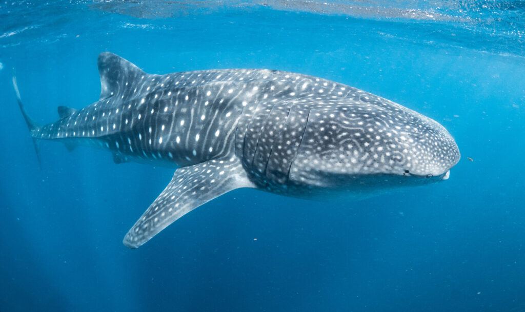
The marine life – turtles, rays, and fish – is the main draw; swimming with the whale sharks here is an iconic West Australian experience.
Exmouth and the North Cape
Exmouth, the base town on the cape’s northeastern tip, has a population of about 2,500. Today it is best known for Ningaloo Reef, but Exmouth wasn’t born that way – the town began in 1967 to support the Harold Holt Naval Communications Centre and navy base, which the Americans used to communicate with submarines. American cars were driven, Greenbacks were used as currency and even a baseball diamond was built here. In 1992, with the end of the Cold War, the Americans withdrew from Exmouth and handed over control of the facility to Australia.
Aside from those within Cape Range National Park, there are dozens of other world-class beaches and swimming spots within easy reach of Exmouth, and one of the pleasures is just finding a patch of sand you can enjoy on your own. The 300m-long Exmouth Navy Pier, 14km from Exmouth, is still in active naval use but may be dived through a tour operator – it is one of the best dive sites in the state, covered in corals and sponges with heaps of marine life swirling around and underneath.
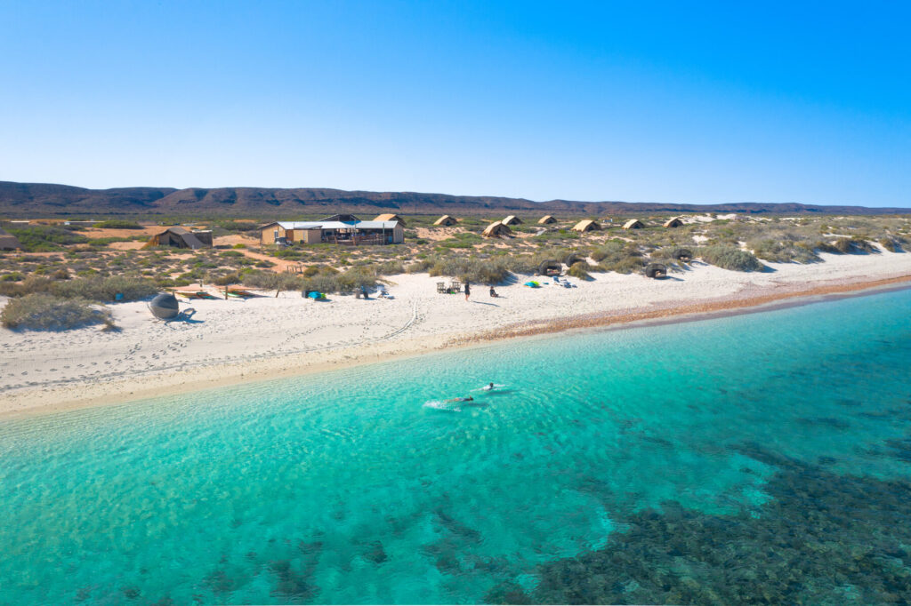
At Lighthouse Bay, 17km from Exmouth, you can see the remains of the SS Mildura, a cattle ship that ran aground in a cyclone in 1907 and is now a marine sanctuary. South of Lighthouse Bay is the nudist-friendly Mauritius Beach, where you’ll also find the Jurabi Turtle Centre – an open-air educational display about the area’s marine turtles. The beach area is a sensitive nesting site for three species of marine turtle: green, loggerhead and hawksbill. From December to March, DpaW conducts turtle-interaction tours leaving from Jurabi – book at the Ningaloo Visitor Centre or at ningaloocentre.com.au. If you are looking to watch nesting turtles, it is highly recommended you visit the website of the Ningaloo Turtle Program and read their ‘Turtle Watching Code of Conduct’.
Purnululu National Park
On the UNESCO World Heritage List since 2003, the magnificent beehive-resembling orange-and-black sandstone domes of the Bungle Bungle Range are the highlight of this Western Australia national park. Some reaching 250m in height, the domes themselves are made of sandstone, and were carved out of erosion from waterways. The distinctive striping is due to cyanobacteria, which require moisture. The darker stripes have their presence, while the orange bands indicate areas of dryness that can’t support the cyanobacteria. Europeans did not first sight them until 1983 – when a helicopter pilot spotted them and took a documentary crew there. They had been known, however, to the Aboriginal peoples who had lived here for at least 20,000 years.
Sometimes Bungle Bungle is used synonymously with Purnululu, but that is a mistake – Bungle Bungle is a range within Purnululu, and the park itself is several times larger. The park is split into two sections – northern and southern – and try to plan your itinerary so that you have ample time to explore both. However, if you have time to do only one side, then make it the southern section – where you can explore the dramatic Cathedral Gorge as well as the beehive domes. Like most things in the Kimberley, the park is subject to seasonal closures. Organised tours will often stop by the end of September because, even by that early on, the temperature in the gorges can be upwards of 50°C.
What to see and do in Purnululu National Park
Northern section
This is home to one of the real highlights of the park: the Echidna Chasm, accessed via a Class 4, 2km return walk from the car park. The chasm is very narrow, often just a few metres wide, but also very tall (up to roughly 180m in some places) – and the light that reflects off the walls makes for a variety of hues – noon is the best time to come for the best colour effect.
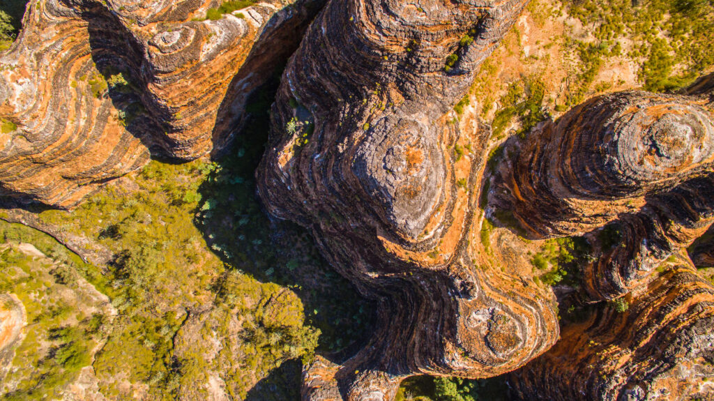
The Mini Palms Trail is another glorious walk (Class 5; 4.4km return), leading to the centre of the Bungle Bungle Range, where Livistona palms grow from the cliffs and down in the gorge. You can access this walk from the Bloodwoods car park or combine it with the Escarpment Trail (Class 3; 7.2km return) from Echidna Chasm, through spinifex, woodland and across dry creek beds. There are lookouts near both the Echidna Chasm and the Bloodwoods car parks.
Southern section
The best place from which to explore the southern section is Piccaninny car park, 27km from the visitor centre. From here, the short Domes Walk (Class 3; 1km return) is a great introduction to the beehive domes, with close-up views of the differing layers of sediment. A longer, scenic walk (Class 4; 2km return) along the beehives leads to the spectacular Cathedral Gorge, a large natural amphitheatre known for its majestic beauty and fantastic acoustics. At the centre is a water pool, surrounded by white sand – the colours reflecting off the rock walls here are simply beautiful, and is one of the park’s highlights.
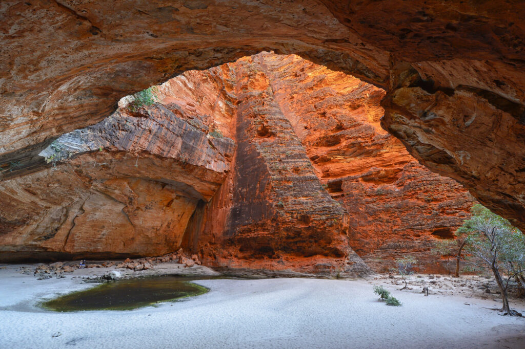
For a real challenge, the Piccaninny Gorge Trek (Class 5; 20km return) explores the park’s largest gorge, delving into the heart of the Bungle Bungle Range with beehive domes, cliffs, seasonal waterholes and wildlife en route, like spinifex pigeons, rock wallabies and skinks. The trail is unmarked and takes at least two days to complete; you must register at the visitor centre before undertaking this hike, and you also need to have a personal locator beacon or a satellite phone.
The southern side of the park also has a pair of good lookouts – Piccaninny Creek (Class 3; 3km return), just past the Cathedral Gorge track, gives a panoramic outlook towards the domes; and The Window (Class 4; 6km return), a striking circular hole in a sandstone dome.
Related books
For more information, see our guide to Western Australia:
Related articles
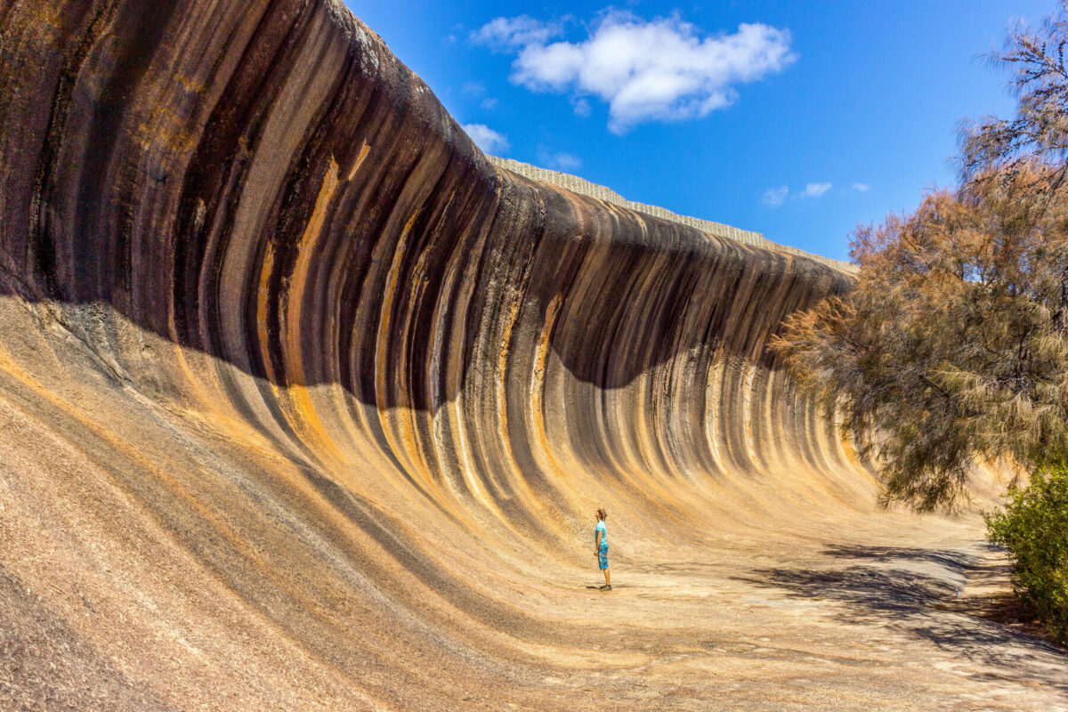
Experience some of the world’s most diverse and dramatic landscapes.
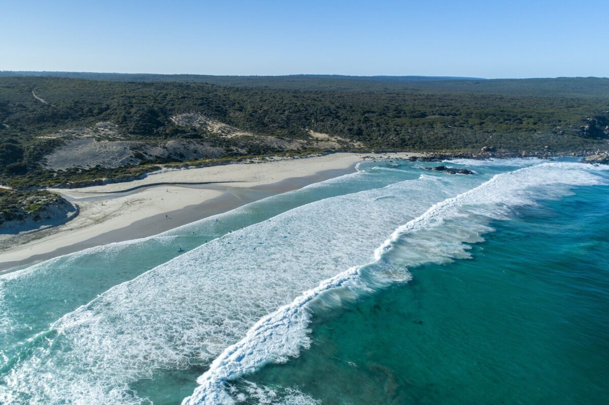
Wine, beaches, caves and history – what’s not to like?