Authors’ tips: England’s best picnic spots
From ancient woodlands and crumbling ruins to mighty waterfalls and glistening sandy beaches.
Picnic season is upon us! We may not get too many sunny days here in England, but once the sun does come out, so do the hampers and picnic blankets.
We asked our Slow Travel authors for the best picnic spots in their local areas. Whether you’re looking for a spot amid ancient woodland or crumbling ruins, next to a waterfall, or on a glistening sandy beach, there’s something here for you.
Chapel Carn Brea, Cornwall
Talk about a picnic with a view! Approached from the narrow, twisting road between Crows-an-Wra and Land’s End airport, this hill is a far-from-strenuous climb, but the visual reward suggests you’ve scaled something much bigger. Having ascended the heathery track from the car park, you can perch with your picnic at the summit on a ruined Bronze Age burial chamber and think you’re lunching on an island, for on a clear day, sea and sky dominate for as far as you can swivel your head.
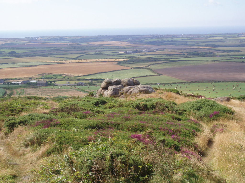
The Isles of Scilly are a smudge on a horizon punctuated by ponderous tankers; smaller fishing vessels plough briskly through the whitecapped swell; and waves which have travelled the Atlantic dash against the Longships lighthouse, enveloping it in dramatic clouds of foaming spray. Away to the east, St Michael’s Mount is palely visible through a gap in the hills, and northwest beyond the offshore twin peaks of the Brisons, there’s a glimpse of Cape Cornwall, believed for centuries to be the real Land’s End.
Ashdown Forest, Sussex
Ashdown Forest is vintage picnic territory. One of Sussex’s most wonderful open spaces, the large lowland heath has almost a moorland character. It’s been carefully preserved by conservators for many years and is almost a mini national park in itself. Wandering deer stray on to the lonely roads, clumps of Scots pines punctuate a skyline that might be in northern England, and Winnie-the-Pooh aficionados tackle a daunting maze of paths in search of literary landmarks.
Car parks are dotted all around the area, meaning there are plenty of spots to pick from; we recommend heading to the Broadstone car park near the Ashdown Forest Centre, from where you can pick up walking leaflets, including Pooh and archaeological trails. Perfect for a post-picnic leg stretch!
Flamborough Head, North Yorkshire
Many of North Yorkshire’s best picnic sites include the ability to gaze out over the water while eating, Flamborough Head is no exception. Pedantically speaking, only the relatively low cliff at the very end of the headland qualifies for the name but when most people talk of Flamborough Head they are referring to the whole area of land between Bridlington and the sands of Filey Bay.
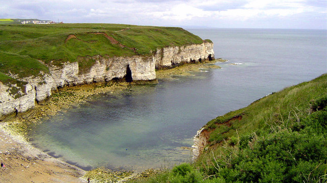
This enormous chunk of chalk, an extension of the Wolds, sticks out a good six miles into the North Sea, with its highest cliffs an awesome, vertical 400 feet at Bempton on its northern side. For the perfect picnic spot, we recommending venturing two miles along the steadily rising cliffs of the northern shore from Flamborough Head itself to North Landing.
Aysgarth Falls, Yorkshire Dales
In the space of less than half a mile that constitutes the Yorkshire Dales’ Aysgarth Falls, the River Ure plunges its 200-foot descent. There is no single spectacular drop but a series of limestone terraced steps at High Force (our recommended picnic spot!), Middle Force, Lower Force and a further unnamed waterfall lower down – let’s call it Bottom Force.
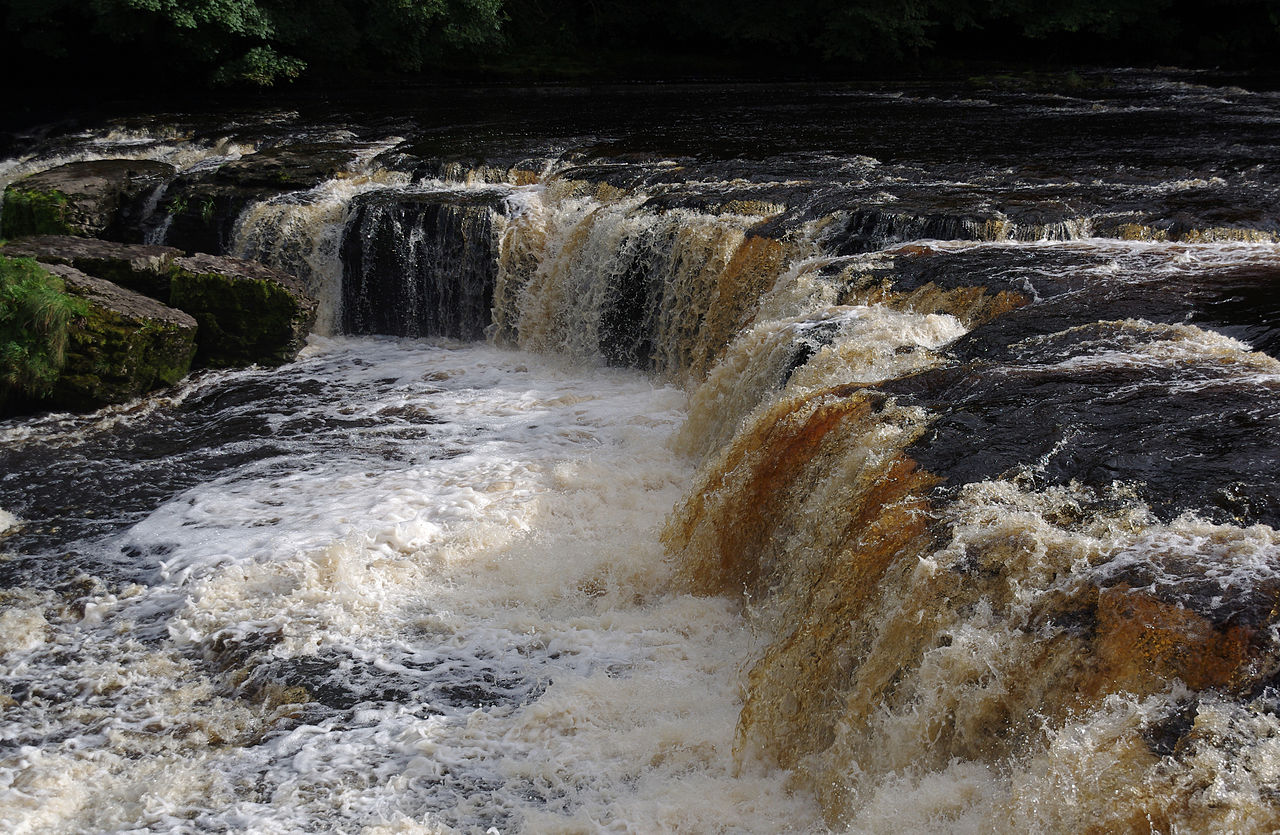
Picnic here after a dry spell and you will wonder what all the fuss is about but if the river is full the name ‘force’ (from the Viking word foss, meaning waterfall) becomes more appropriate and the roar of the combined drops can be heard a long way away.
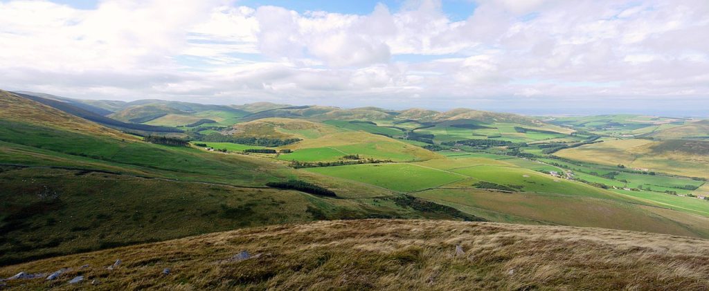
Racecourse Common, Shropshire
Straddling the B4580 just northwest of Oswestry, on the plateau of a hillside called Cyrn y Bwch – the Horns of the Buck – Racecourse Common is an ideal place to spend a few hours walking, picnicking, and perhaps learning about the common’s history. On a clear day you can see across Shropshire and the Cheshire Plains to the east and Wales to the west: a double-headed stone horse shows you which way you’re facing.
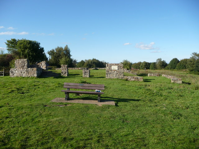
Installed in the 1990s, this statue commemorates the common’s history from the early 1700s to 1848 as the venue for an annual race meeting. Most of the famous families from the area were involved in some way at some time; John ‘Mad Jack’ Mytton is known to have revelled with the best and worst of them. Spectators who could afford it cheered from the stone grandstand, the ruins of which you can see today.
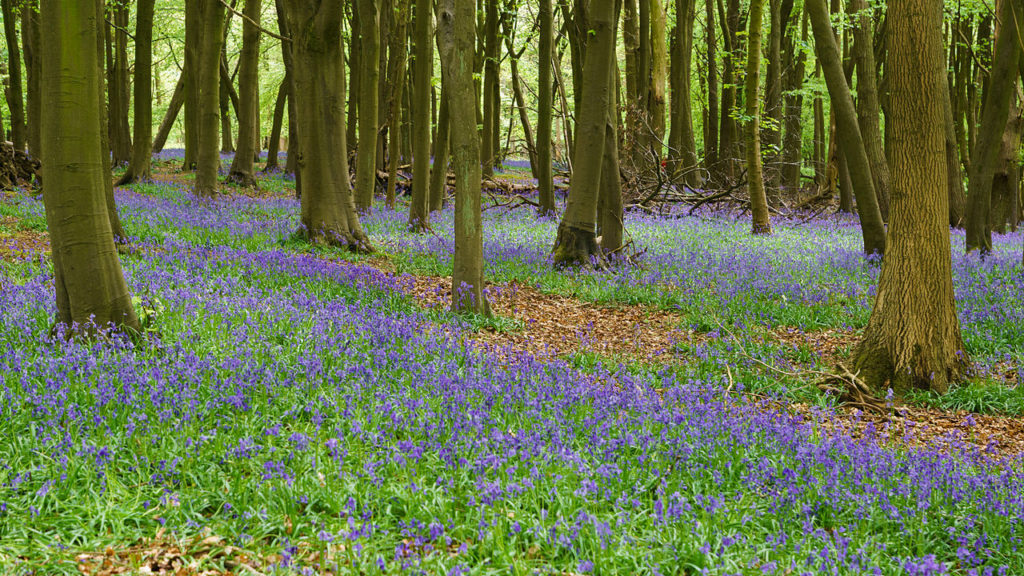
Picnic here in spring and you’ll spot bluebells and tunnels of bracken; in early autumn rowan trees on South Common are at their bright berry best. Also look for holes burrowed by small mammals: moles, shrews, squirrels, rabbits, weasels and even polecats have made this grassland their home.
Ashridge Estate, Chilterns
This wonderful estate comprises 5,000 acres of land on the Hertfordshire–Buckinghamshire border. Originally there was a medieval monastery here, run by Bonhomme monks; Edward I held a parliament here in 1290. Later, after briefly being in the ownership of Henry VIII and his children, the estate came into the hands of the Egerton family in 1604. It has been managed by the National Trust since 1926.
The landscape includes oak and beech woodlands, chalk downlands and commons, each supporting a different range of wildlife. The estate is crossed by a network of footpaths, bridleways and cycle paths. If you’ve forgotten to pack your own food, don’t worry – the Brownlow Café near the visitor centre serves breakfasts, light lunches and even afternoon teas.
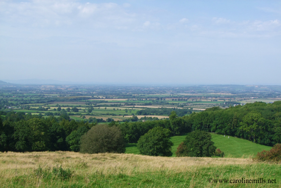
Dover’s Hill, Cotswolds
Dover’s Hill is a ridge that sits between the two villages of Weston-sub-Edge and Aston-sub-Edge – both ideal locations to pick up some local fare to picnic on. Owned by the National Trust, it is a massively famous landmark in the area, and with free access for walkers. What’s so special about the hill is the diversity of the landscape within such a small area. At the very top are the incredible views over the Vale of Evesham – a pictorial map pinpoints notable landmarks.
Along this flat ridge run the very beginnings of the Cotswold Way, a curious dog-leg from its starting point in Chipping Campden before walking southwest. The hill then falls dramatically away, yet only for a few feet before this undulating landscape creates watering holes, small pockets of woodland and warm patches in the sunlight of the open field. Further down the ridge lies the Lynches Wood, where a circular footpath takes you on a journey under the canopy.
Slippery Stones, the Peak District
For fans of wild swimming, Slippery Stones on the River Derwent above Howden Reservoir in the Peak District is the the perfect place for a post-dip picnic. It can get busy though, despite its isolated moorland location, and you will need to arrive early or late in the day if you seek any sense of solitude.
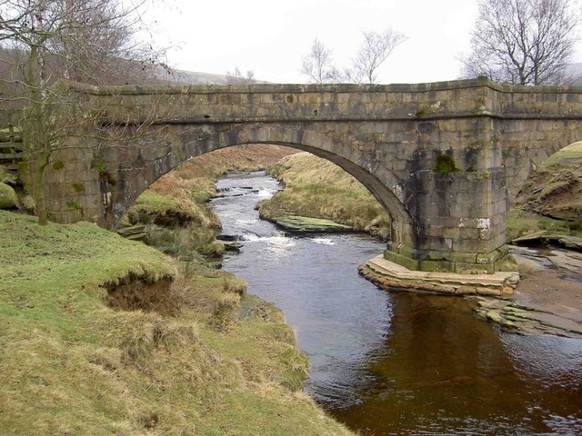
There’s a frothy pool, ten to 12ft deep, containing fresh water tinged brown from the peat – a bit like swimming in fizzy coke, as one wild swimming enthusiast observed. The rebuilt packhorse bridge is all that remains of Derwent village above water; the village drowned when the valley was flooded after the building of Ladybower.
College Valley, Northumberland
This six-mile-long glacial valley is the most isolated and tranquil of all the major valleys in Northumberland’s Cheviot range. Its seclusion is helped by the fact that only 12 permits a day are issued for access by car. Some of the best Cheviot hill walks are reached from College Valley, meaning there picnic spots are plentiful, but our recommended spot is at Three Sisters, a trio of small waterfalls.
To reach here, take the well-trodden path from Mounthooly bunkhouse at the southern end of the valley, following College Burn in the direction of the Hen Hole – a dramatic chasm under the Cheviot. Hiking all the way through and up the Hen Hole is one for serious hikers, fell runners and climbers, but if you go a little way up, you’ll come to a series of little falls with bathing pools and enough soft grass nearby to pull out a picnic blanket.
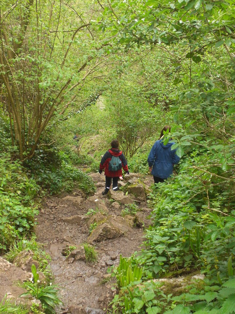
Ebbor Gorge, Somerset
If you’re looking to picnic in peace in Somerset, this gorge is the place to head to! It is almost deserted compared with Cheddar Gorge. The gorge was created some 270 million years ago following the collapse of a huge cavern. Defined by craggy limestone outcrops and towering cliffs cloaked in ancient ash woodland, the caves that pockmark the gorge once sheltered both humans and animals, among them cave bears, wolves and arctic lemming, as recent finds testify.
The main, moderately strenuous trek through the gorge doesn’t take much more than an hour. From the car park, descend to the valley floor, sheltered by thick, damp woods before a fun little scramble up through a narrow ravine, at the top of which the path loops round to a clifftop plateau (another deserving picnic spot). From here, a stepped path brings you back down to the bottom of the gorge.
Holkham Beach, Norfolk
No question, Holkham Beach is one of the finest in not only all Norfolk, but also all England: a wide swathe of glistening sand backed by dunes and a thick stand of Corsican pines; the sea, a softly lapping presence or a thin line on the horizon, depending on the tide. Whatever the state of the tide, it’s a wonderful beach for bathing and about as safe as it gets for children, making it a perfect place to picnic.
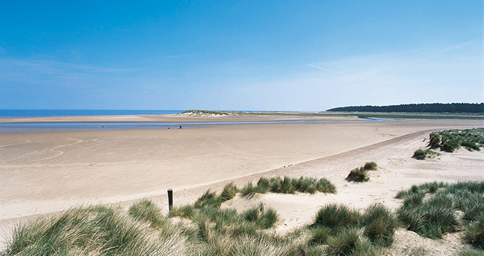
The provision for parking here is considerable but so are the crowds that come here on warm summer days. Once parked up, however, there is plenty of sand for everyone – the beach is a vast expanse that stretches as far west as the dunes at Gun Hill next to Burnham harbour creek, and east to The Run at Wells-next-the-Sea.
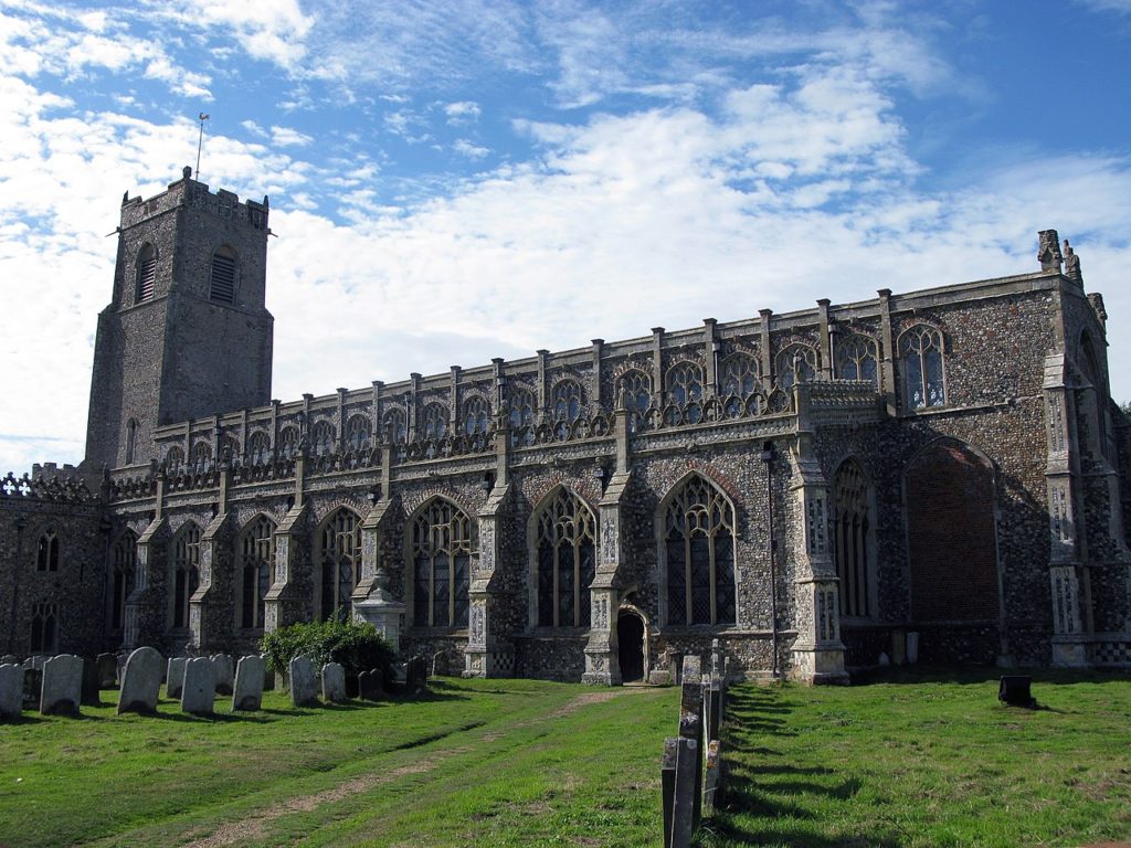
Blyth estury, Suffolk
A few miles inland from Southwold at the head of the Blyth estuary, the Suffolk village of Blythburgh clusters around the busy A12. The estuary itself is quite a sight, especially when the tide is in and its wading birds are squeezed in closer to view, but the major attraction here is undoubtedly the village’s remarkable church.
Just south of the village, at the junction of the B1387, is the Toby Walk’s picnic site, named after the ghost of a dragoon drummer reputed to haunt the area. The footpath that follows the southern shore of the estuary in part traces the route of the former Halesworth to Southwold railway.
A lovely linear walk is along the river path from Wenhaston to the church at Blythburgh, before taking the estuary path that leads through woodland to eventually join the Sandlings Walk for the last couple of miles into Southwold.
Beeston Castle, Cheshire
Fancy picnicking amid a tumble of ruins? Pack up your lunch and head to Cheshire’s Beeston Castle. Ranulf, Earl of Chester, built this castle in the sky in the 1220s. But the discovery of flint arrowheads from the Neolithic period suggests prehistoric man was the first to spot this vantage point, plus there’s evidence of a Bronze Age community and an Iron Age hill fort, the latter being used as a foundation for the outer bailey walls of the 13th-century castle.
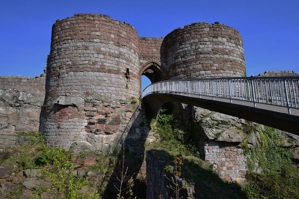
The ruins are reached via a modern bridge, which spans a deep ditch that once repelled invaders, to deliver visitors into the mouth of the huge gatehouse from where it’s possible to explore the remaining towers and embattled curtain wall, and see one of England’s deepest castle wells, with a 370-foot drop.
Beeston’s vantage point on the crag, with sheer cliffs on three sides, made it a formidable stronghold, commanding stupendous views from the Pennines to the Welsh mountains that visitors still enjoy today. There are also 40 acres of woodlands in which to gambol here.
More information
Discover more places to picnic with our Slow Travel guides:
Lead image © Deval Parikh, Unsplash