Central Africa: an overland adventure
Travel Gabon, Congos, Angola and Namibia by car!
Central Africa is a region of outstanding natural beauty. Comprising of southern Chad, Cameroon, Gabon, Central African Republic (CAR), Congo, Democratic Republic of the Congo (DRC) and Angola, the area has been a popular choice for overland travellers for decades. With plenty of rain and mud to slow you down, this is where a 4×4 really comes into its own.
The following journey begins in Gabon, travelling via Congos and Angola before finishing in Namibia. Showcasing impressive landscapes, bustling cities and, of course, some of the most exciting roads in Central Africa, this is one route you don’t want to miss.
Gabon
Heading south from Yaoundé, the road is good but hilly tarmac and very pretty, with dense jungle and occasional distant mountain ridges. From Ambam there are two routes. The main one heads south from town to the Ntem River, where a new bridge must surely be finished by now. Then a wide road heads towards Equatorial Guinea. East of the border post of Meyo, the route was a dirt track to Bitam in Gabon. The other route heads east from Ambam on a very narrow muddy track with ageing log bridges. A friendly ferry crosses the river here to Gabon. Most formalities are carried out at Bitam.
Going south in Gabon, the road should all be tarmac to Libreville and well past Lambaréné. Again the scenery is spectacular. The road from Ndjolé to Lopé National Park is little more than a country lane and very hilly. The road has deteriorated in the last few years, but if you have plenty of time it should be OK, though slow and isolated. Fortunately, after Lopé the road improves, with more hilly sections but a better road surface. It should, under normal circumstances, be possible to drive from Lopé to Lastoursville in a comfortable 6-hour day. The route improves between Lastoursville and Franceville and may take only 3 to 4 hours.
Gabon highlights
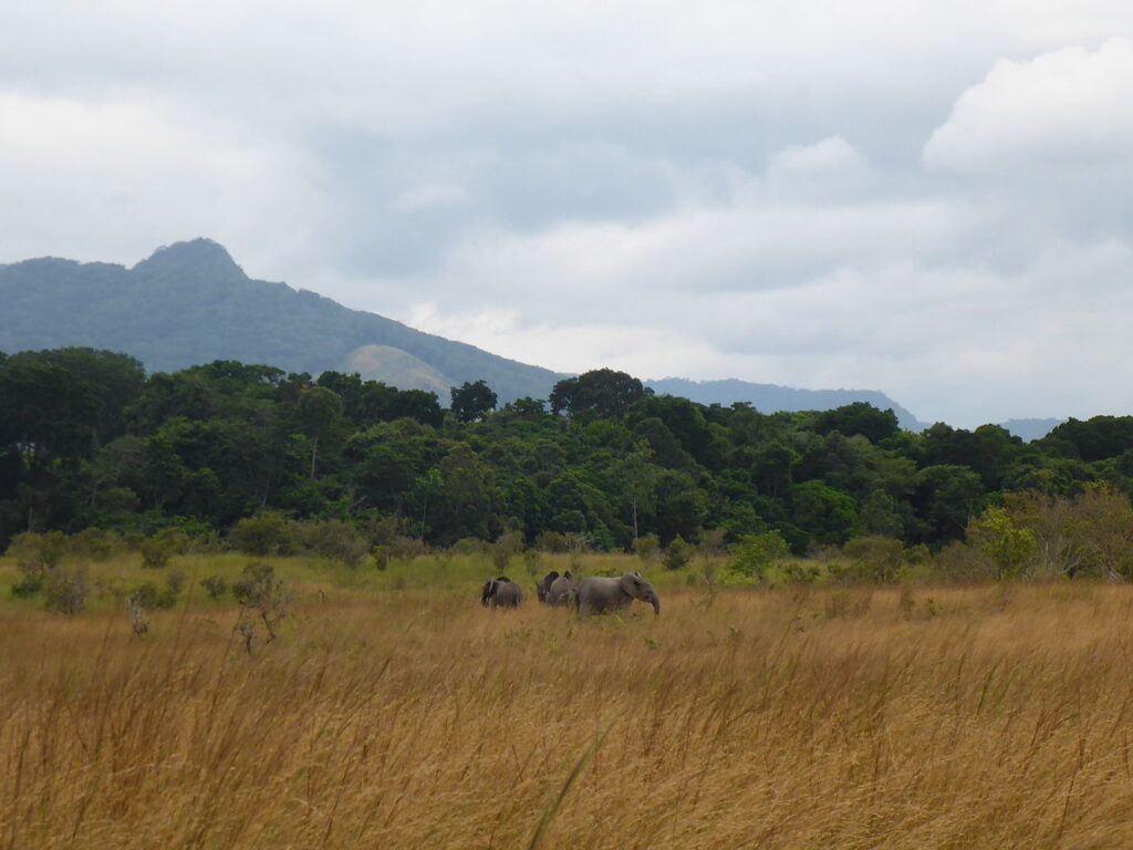
In Libreville are extensive local markets, and a few resorts along the ocean as far as the beach at Cap Estérias. Lambaréné is set on the beautiful banks of the Ogooué River, with the Albert Schweitzer Hospital and Museum. Gabon has extensive virgin forest covering very hilly country, which can be seen by visiting the various reserves. The parks are host to lowland gorilla, forest elephants and chimpanzees.
The most famous is the Réserve de la Lopé, where one can go in search of lowland gorillas. Tours are expensive; two days with one night here costs US$400. For the Moukalaba-Doudou National Park, a three days/two nights tour costs US$400. The remote Ivindo National Park (including Kongou Falls) can be visited for three days/two nights for around US$600.
Congo
There seem to be two potential routes from Franceville around the Congolese border area. According to Paul Telfer of WCS (Wildlife Conservation Society) in Franceville, a small sandy track leads from the Batéké Plateau into Congo and on to Lékana, where roads of a sort lead to Ngo on the main Owando to Brazzaville road. We have only sketchy information about this route, so you will have to ask around in Franceville about its viability.
Most others have reported heading due east from Franceville to Lekoni (Leconi), where some canyons make a good if hairy diversion. A short new section of Chinese-built tarmac exists here. The border of Congo is 30km further east (marked as Akou on the Michelin map). Immigration is done in Mbie. It’s around 125km between Lekoni and Okoyo, the first settlement of any size in Congo. Apparently a new road runs east through Boundji to Obouya on the main road.
To reach Parc d’Odzala, go north and then west on sealed roads to Etoumbi, from where a dirt road heads north to the park through Mbomo. Otherwise heading south now on a mostly good tarmac road, you come in 160km to Ngo, where the route runs adjacent to the Réserve du Léfini. The reserve is not very active. There is a scenic escarpment where the road climbs steeply near Etsouali. The road is mostly good tarmac, not through much rainforest but via rolling open moorlands to Brazzaville.
Congo highlights
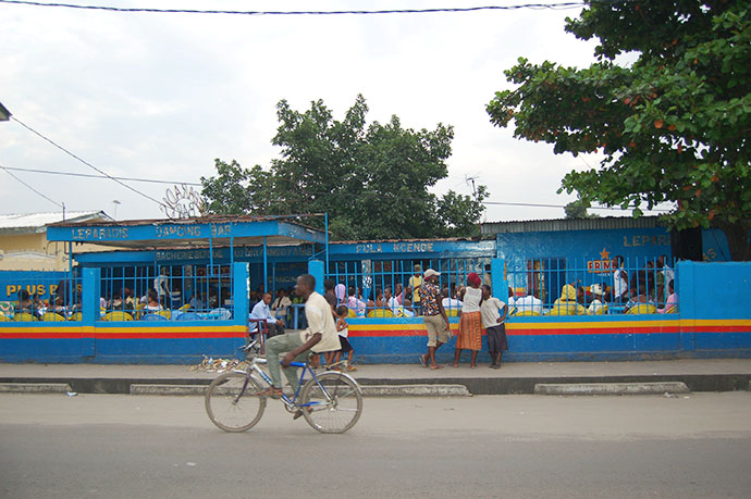
Brazzaville is a lively and also mellow place. Congolese music and food are well-known bonuses of a visit here. Then there are the beaches around Pointe Noire and the nearby Jane Goodall Chimp Sanctuary. In the north, close to Gabon, isolated in dense rainforest, is Parc National de Odzala, known for its gorilla trekking.
Close to the CAR border, in the far north beyond Quesso, and adjacent to the Dzanga-Sangha reserve, is the Nouabalé-Ndoki Park. It’s not a cheap experience – from US$1,600 for five days. This should include shared transport from Quesso to Bomassa and to the different sites in the park, accommodation, food, guides and entry taxes. Some other bad roads of Congo are another highlight if you like that sort of thing!
DRC
From Brazzaville you have to cross the river to Kinshasa. The actual ferry takes little time, but formalities make this an all-day affair. Expect to bargain for the ferry tickets. Do NOT take any photos of the Congo River from anywhere, or get cameras out either, anywhere near it. They will confiscate the lot. This also applies to the bridge crossing at Matadi.
From Kinshasa to Matadi, the road is in a variable state. If you have been lucky enough to get your Angola visa in advance, you will not actually need to go as far as Matadi. Currently the turn-off for Angola is in the small crossroads town of Songololo, 81km east of Matadi. Be sure to get your carnet stamped here. A poor dirt road goes south to Luvo, with the DRC immigration 11km from the turn- off. Another Angolan border at Noqui, close to Matadi, has been used by Oasis Overland. A pretty awful stretch of dirt then leads to Tomboco.
DRC highlights
In the east is the Parc National des Virunga, known for its gorilla trekking and volcanoes (although access has beed affected by the civil war). Climbing the Nyiragongo active volcano is spectacular – too spectacular – it is on the boil constantly and erupted again in 2020. The Epulu reservation for the mysterious okapi was open to visitors before the security issues in the north-east. Mount Hoyo offered a cool respite and numerous caves and interesting rock formations but rebel activity in the area continues. Don’t forget the music of the DRC. And if it becomes safer, there are even worse roads to test your driving skills, your vehicle and your staying power.
Angola
After another 3km from the Luvo check-post you reach the Angolan immigration. The infrastructure in much of Angola is still in a bad way; mines are still a big hazard away from the main routes. Possibly impassable in the wet, the next 75km is a single-track route with a few sealed bits on to M’banza Congo. The small ruined church was the first Catholic place of worship built in central Africa.
In very good weather conditions, you might get as far as the delightful beaches south of N’zeto. The road surface, though, changes a lot, from new tarmac to lousy. The distance is around 300km from the border through Tomboco to N’zeto, of which about 200km is sealed. Don’t expect any good road to the capital from N’zeto. The coastal road is still to be completed to Caxito. The road from Caxito on to Luanda is much better, but there could be endless check-posts on the way. Once in Luanda, beware of theft and street crime. Luanda is also one of the most expensive cities in Africa.
There is now a choice of route to the south. Latest reports from travellers who have made it into Angola suggest that many new Chinese-built roads are now completed. From Luanda to Lubango via Huambo can be done in just two long days on good, surfaced roads. The entire 640km to Huambo can be navigated in one very long day. The first section of good road goes to Dondo. The scenery is more varied from here on and the road newly rebuilt all the way to Huambo. From here the next 400km or so to Lubango is also new tarmac road.
Heading south via the coastal route it will take a couple of hours to the Parque Nacional da Quicama, but at least you’ve got through the capital. With interesting, varied scenery and a new road, the coastal trip down to Benguela could take a day (or two allowing for a side trip to the Quedas de Água do Binga waterfalls). From Benguela the best road, which is at times scenic with rocky outcrops and baobab trees, is via Chongóroi and Quilengues to Cacula where it joins the main Huambo road to Lubango.
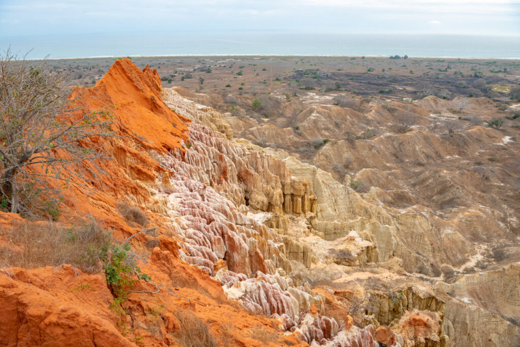
If you are continuing along the coast, be sure to follow the correct road to Santa Maria and on to Lucira. The route is not yet rebuilt and is said to be slow. Closer to Namibe the road improves, then you head inland to Lubango. The road is mostly OK as it climbs into high country with great views. Lubango is likely to become the tourist destination of southern Angola, as more people discover its long-unexplored delights. Above town and with great views is the Statue of Christ, looking like the Corcovado version above Rio in Brazil. The fantastic Tunda-Vala Gorge is the prime destination, about 17km from Lubango. Carved from the Chela Escarpment, sheer 1,000m cliffs drop into a verdant green canyon; don’t miss it!
The road south to the border with Namibia is via Cahama and Humbe. There is also a possible optional road through Otchinjau direct to the Ruacana Falls border with Namibia.
Angola highlights
South of N’zeto are turbulent rivers, savanna, jungle and some beautiful rock formations, all close to the sea. The Ponta das Palmeirinhas south of the capital offers a viewpoint where some unusual rock formations are seen. Benguela is a pleasant stopover; check out the Cuban-built communist-style housing.
Lubango is likely to become the tourist destination of southern Angola, as more people discover its long-unexplored delights. Close to town, take a walk up to the Church of Our Lady. The Serra da Leba pass, 45 minutes out of town, and the town of Humpata, an old Boer settlement, are along the road to Namibe. Also outside Lubango is the Tunda-Vala volcanic fissure gorge, with 1,000m cliffs, all viewed from various panoramic platforms. In the southwest is the extensive Serra da Leba mountainous region inland from Namibe. In the far south are the Quedas do Ruacana waterfalls, when flowing, on the border with Namibia.
Namibia
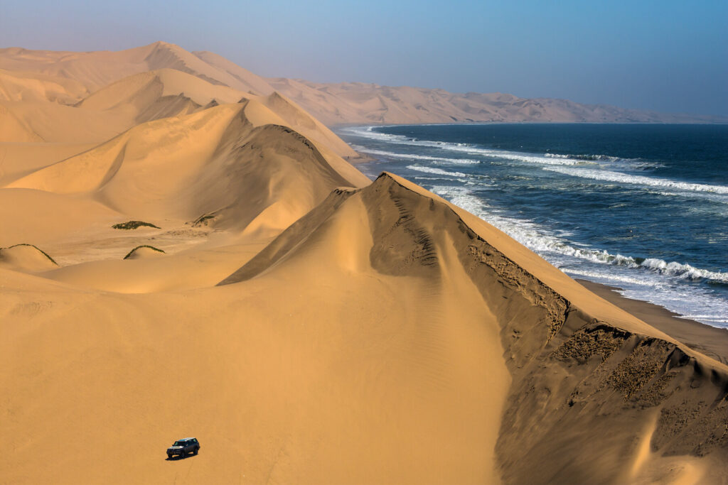
Once in Namibia, the roads are a joy and so is Etosha National Park. It’s one big holiday from here on, whether down to the Cape or back up to Nairobi. The country has a long list of highlights, including Windhoek. The amazing orange/red dunes of the Namib Desert, seen at their best at Sossusvlei, are spectacular. Swakopmund and Lüderitz have relics of the German colonial period.
In the northwest is Kaokoland, with its beautiful scenery and Himba people. Then there are the national parks, including the world-famous Etosha, plus the Waterberg Plateau, the Skeleton Coast, Fish River Canyon, Kalahari Gemsbok and Namib Naukluft, all with varied wildlife. In the northeast, the Caprivi Strip strikes east across northern Botswana.
Practicalities
The easiest time to travel is in the drier season from about December to February. There is also a ‘less wet’ season in June/July. The rain barriers set up on roads during the rainy season could cause you considerable delays. Most of these routes have been closed to travellers for years, but hope springs eternal for crazy overlanders.
Although the security issues on these routes have improved, the bureaucratic obstacles have increased. Check the security issues between Dolisie and Brazzaville now that peace has broken out. Consider the route via Franceville to reach Brazzaville, since new road building has improved the route with sealed sections. Ask locally to confirm no sections have deteriorated.
Since 2014, more travellers are trying routes via the DRC. Oasis Overland, one of the leading overland truck operators, runs trips on this route via Cabinda. Hopefully the situation will improve, encouraging tourist dollars into areas of outstanding natural beauty. That said, it is likely you will still encounter some gun-toting soldiers, difficult bureaucracy and bad roads – the worst country being the DRC. Cameroon generally and Gabon are fairly stable at the time of writing, but visas for the region are increasingly expensive.
More information
For more information, check out our guide: