Wondering where to take photos in Britain? This selection of spectacular spots from author and photographer Will Gray has you covered.
I spent two years researching my guide to Photography Weekends Britain, travelling the length and breadth of Britain to capture every image you’ll find in its pages and in this article.
As a lifelong Canon user, photography is more than simply a job to me – it’s an intrinsic part of daily life; a way of connecting with nature and taking the time to pause and appreciate the beauty and diversity of landscapes and wildlife that are increasingly under threat.
Researching this book has been one of the most rewarding and challenging projects I’ve ever undertaken. The variety of scenery in Britain is simply staggering. Combine that with the quality of the light and the subtle pulse of the seasons and you have a photographic destination that’s unrivalled anywhere in the world.
From the wild coast of Cornwall to the rugged Isle of Skye, these are just 10 of my favourite spots. For the full list, you’ll have to get the guide…
Get the guide to photographing Britain
Before you delve into the article, check out the guide to photographing Britain that inspired it:

Where to take photos in Britain
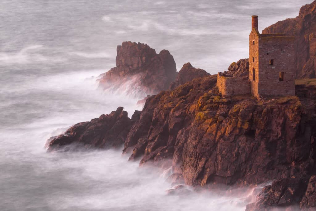
Crown Mines
Botallack, Cornwall
Before you reach for your camera, spare a thought for the miners who burrowed half a mile out to sea and up to 1,870ft deep at the Crown Mines. From 1815 to 1914, over 14,800 tonnes of tin, 22,400 tonnes of copper ore and 1,500 tonnes of arsenic were cajoled from its submarine shafts. What you see today are the remains of the buildings that housed the steam engines used to power the mines’ water pumps and winches.
The Crowns are a gift for photographers.
Sprouting from wave-pummelled cliffs, the pair of buildings are perfectly positioned to accentuate the diagonal slope of the headland. Experiment with a zoom lens until you find a composition that achieves a balance between the land and sea.
Two things can elevate your images here: long exposures smooth out ‘messy’ waves to emphasise the strong diagonal rock strata, while late-afternoon and early-evening sunlight defines the engine houses themselves, outlining that crucial ‘chiselled vertical’ in what could otherwise be a fairly chaotic scene.
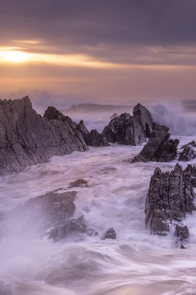
Hartland Quay
Hartland Peninsula, Devon
A harbour wall was built at Hartland Quay at the end of the 16th century to facilitate a trade in lime, slate, coal and barley. The arrival of the railway in Bideford, combined with relentless Atlantic storms, consigned the quay to oblivion by the end of the 1890s, returning this austere coastline to its original wild state. Workers’ cottages, stables and a malthouse have since been converted into the Hartland Quay Hotel – a stone’s throw from one of the most dramatic stretches of coast in Britain.
Down on the shore, among the contorted strata and black ribs of shale, Hartland Quay reveals its true character. Pick your way carefully over the rocks, looking for ledges that act as lead-in lines, and prominent jagged outcrops for strong focal points. A falling mid-tide is best.
Position yourself so that you can capture waves gushing in and out of narrow channels formed by the ledges. Dusk can be stunning, particularly if the sinking sun backlights spray from wind-combed rollers. If you photograph here on an incoming tide, make sure you have an exit strategy – a clear and quick route back to the slipway so that you don’t risk getting cut off by the tide.
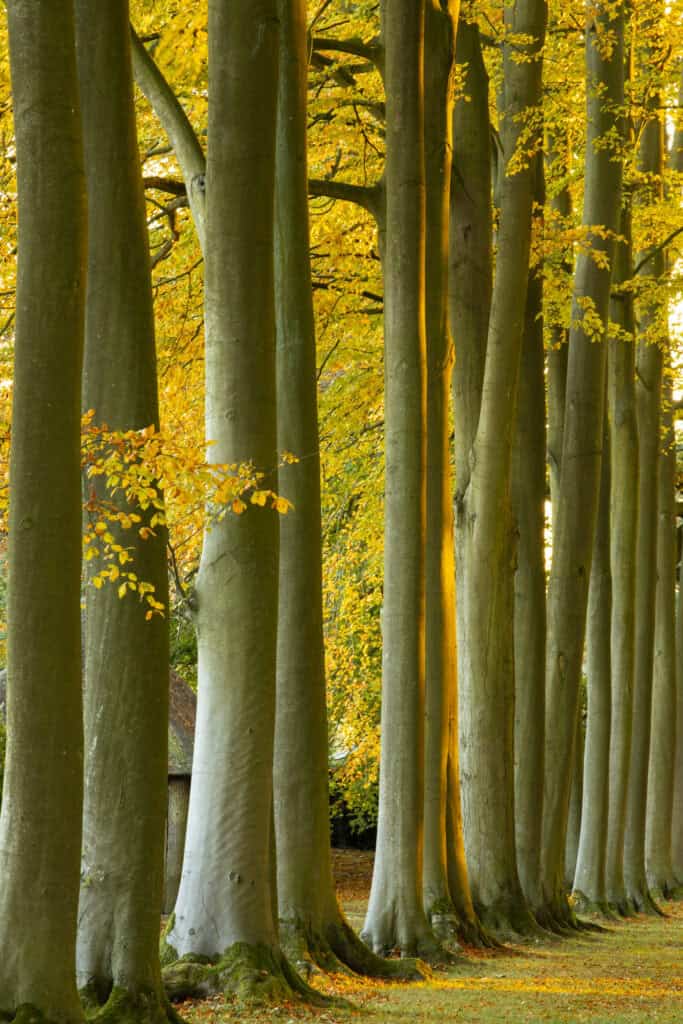
Hidcote Manor Garden
Gloucestershire
When Lawrence Johnston bought Hidcote in 1907 for £7,200 there wasn’t much of a garden, so the horticulturist set about creating a series of interconnected ‘rooms’ around the manor house, filling them with rare species from his plant-hunting expeditions in Europe, China and South Africa. The result is one of the world’s great gardens – a blueprint for contemporary garden design and a goldmine for photographers seeking images of everything from formal pool reflections to rampant herbaceous borders.
Aim to visit as late as possible for the best light and fewer visitors. Two particularly fruitful areas to focus on are the red borders (with elegant gazebos and a pleached lime hedge at one end) and the circular bathing pool with its reflections of a magnificent magnolia.
A spectacular beech avenue can be photographed from a footpath (without entering the gardens). Try a wide-angle lens and low ‘horizon’ to exaggerate the tall, graceful beech trunks. The formality of this line of trees creates a strong pattern of repeating verticals that is simplified and emphasised by using a telephoto lens to concentrate on just one side of the beech avenue. Although ‘busier’, a wider view can also be effective, particularly with the gateway in the yew hedge at the far end of the avenue acting as a natural vanishing point.
- Recommended reading: the best historic houses in Britain
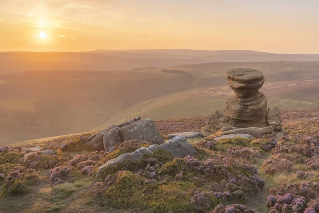
The Salt Cellar
Derwent Edge, Peak District
It’s not hard to see why the Salt Cellar is such a popular landmark for Peak District photography. The millstone tor is located just below the ridgeline of Derwent Edge, rising about 12ft above the heather-carpeted moorland. I arrived a good hour before sunset to scout out potential compositions – and enjoy the view.
There was enough cloud on the horizon to diffuse the direct sunlight, allowing me to shoot towards it without too much flare and capture the backlit heather, as well as some side lighting on the rocky pedestal and the golden glow in the valley. I bracketed the exposure (one stop under and over) and used a ND graduated filter to help control the brightness in the sky. My visit was timed for peak heather-flowering season in the second half of August.
I wish I’d remembered my headnet – the midges were out in force at dusk! I liked the way the slabs of rock acted as both a counterbalance to the Salt Cellar and a strong diagonal element in the composition from the bottom left corner of the frame.
- Don’t miss: Is the most beautiful walk in the Peak District?
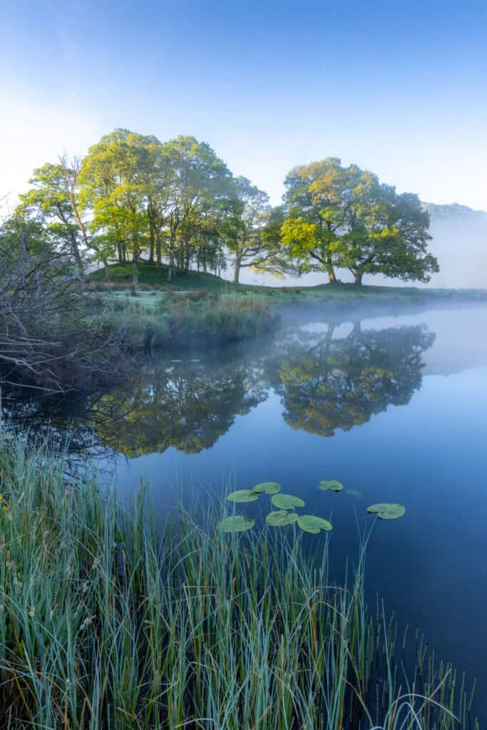
Elter Water
The Lake District
Rising high in the fells around Wrynose Pass, the River Brathay starts life as a fiesty, foaming beck, but by the time it reaches Elter Water, it’s calm and serene – so still in fact that it often carries a blanket of mist on cold mornings. There’s no better spot for a gentle introduction to the Lake District.
Park in the National Trust car park on the edge of the village of Elterwater and follow the riverside path for about 20 minutes. Keep walking through a small patch of woodland. In spring, the scent of wild garlic and a dawn chorus of blackbirds, cuckoos, wrens and redstarts are invigorating. Emerging into the open again, you’ll spot Elter Water’s twin oaks standing sentinel on the riverbank ahead.
The sun rises to the left of the trees, enflaming the surrounding mountains before slowly creeping into the woodland canopy. As the leaves glow in the sunlight – autumn gold or spring greens – the reflections in the water intensify.
Try positioning yourself near the riverbank to include foreground details such as lily-pads, sedges or marsh marigolds. Even before the sun rises the scene is sublime. So, get there early, set up and keep shooting right through the early morning, capturing the shifting mood as veils of mist drift through the valley.
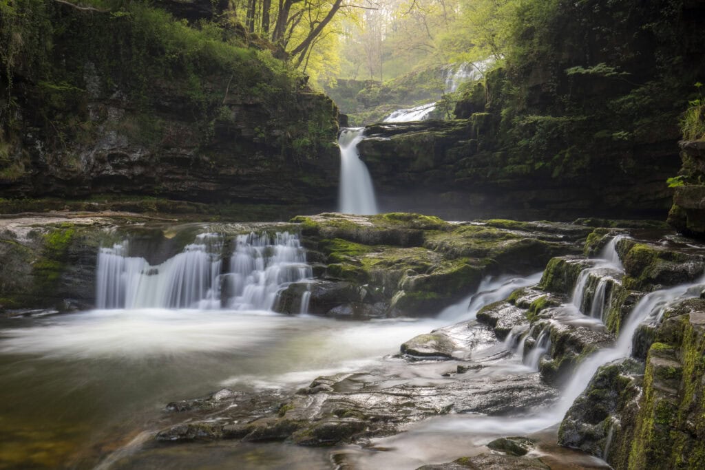
Waterfall Country
Brecon (Bannau Brycheiniog)
In Waterfall Country, a wedge of land located between the villages of Pontneddfechan and Ystradfellte, shallow rivers and streams have gouged fern-filled gorges where a series of cascades plunges over cliffs and ledges surrounded by ancient woodland. Follow the Four Falls trail and you’re in for a spectacular morning of waterfall and woodland photography.
Descending through oak woodland, the trail crosses the Afon Mellte on a footbridge near the first waterfall, Sgwd Clun-Gwyn (Fall of the White Meadow). Follow the red marker posts downstream to Sgwd Isaf Clun-Gwyn (Lower Fall of the White Meadow), a more interesting cascade that’s divided into two main sections. The lower part consists of a narrow plume of water flowing into a mossy amphitheatre marbled with smaller falls and torrents. It’s a magical setting.
Green waymarkers lead you alongside the river to a rocky outcrop level with the top of Sgwd y Pannwr (Falls of the Fuller). A graceful old oak drapes a bough across the front of the waterfall, creating a strong diagonal element that mirrors the cascades pouring over terraces into the pool below. Sit quietly here and you’ll almost certainly spot dippers and grey wagtails.
The fourth waterfall, Sgwd yr Eira (Falls of Snow) is reached via a steep flight of steps down into the gorge. A delicate curtain of water, the multiple strands of these falls make a beautiful study in their own right – particularly with morning light filtering through the trees above.
Llyn Y Dywarchen
Eryri (Snowdonia)
Sometimes, when low cloud slumps over central Snowdonia, this idyllic little fishing lake on the western edge of the mountains can be bathed in sunshine. It offers a spectacular view of Yr Wyddfa (Snowdon), especially when warm afternoon light brushes its slopes.
To reach Llyn y Dywarchen, drive 3½ miles north of Beddgelert along the A4085 to Rhyd-Ddu. Turn left on the B4418 just after the Cwellyn Arms pub and drive uphill for about a mile until you reach a walled parking area on the right. Walk through the gateway towards the lake and the photographic opportunities come thick and fast. For starters, there’s the boathouse and rowing boats right in front of you. But chances are you will be lured up the small hill on your right for panoramic views across the lake towards the cloud-snagged summit of Yr Wyddfa and the peaks of Foel Rudd and Mynydd Mawr.
In winter, be sure to time your visit so you get here before the sun disappears behind the bulk of Y Garn and casts a shadow across the lake. A path loops around Llyn y Dywarchen. Fence-lines marching into the water add foreground interest, while ruined stone barns make interesting photographic studies in their own right.
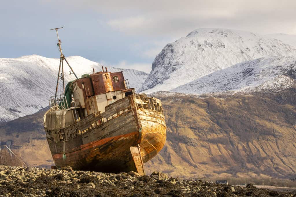
Corpach
Fort William
When the Golden Harvest (formerly known as the MV Dayspring) broke her moorings during a storm in 2011, the coastguard guided the 85ft-long fishing boat to her final resting place, high and dry on the shores of Loch Linnhe. As luck would have it (for photographers at least), the vessel, built in 1975, settled at a jaunty angle with Ben Nevis perfectly positioned in the background. And as if a battered old shipwreck beneath Britain’s highest peak wasn’t reason enough for a photograph, it turns out that the ‘Old Boat of Caol’ is also easily accessible.
A 5-minute drive from Fort William along the A830 takes you to Corpach where Kilmallie Hall car park is just a short stroll from the mouth of the Caledonian Canal. Cross over the lock gates here and you can walk a few steps on the Great Glen Way before veering off on to the beach. A mixture of mud, shingle and seaweed, Loch Linnhe’s shoreline calls for wellies, especially as you may need to wade through a shallow stream as you approach the wreck.
A low viewpoint not only ‘lifts’ the wreck, nudging Ben Nevis into a more dramatic spot in the background, but it also means you lose some of the distracting rooftops in the distance. Low tide works best for this approach, otherwise you may be restricted to less-flexible viewpoints higher up the shoreline. Once you’ve taken the classic shot of the wreck, walk right up to the stricken vessel to explore its wonderful textures and colours.

Loch An Eilein
Cairngorms
Stretching from the River Spey at Aviemore to 4,252ft Braeriach (Scotland’s third-highest peak), the Rothiemurchus Estate covers nearly 25,000 acres of ancient Caledonian Forest – and right at its heart you’ll find Loch an Eilein, glinting like a jewel from the rugged folds of the Cairngorms. Just 4 miles from Aviemore, it’s not only a convenient sunrise location, but a particularly beautiful one.
From the car park, walk down to the loch shore and you’ll spot a small island in the distance. Loch an Eilein is Gaelic for ‘Loch of the Island’ and you can just about make out the ruins of a 13th-century castle peeping through its trees. The woodland path to your right offers a closer look, but for sunrise the best viewpoint is a short distance along the shore in the opposite direction. Walk to your left until a pair of tall pines on a small promontory comes into view, silhouetted against the mountains at the far end of the loch.
Shortly after sunrise, light catches the western shore and enflames the island. All three elements – the pines, the island and the sunlit shore – work well as a panorama. Alternatively, choose a shorter focal length and frame the view with overhanging branches of pine and birch. Early-morning mist adds atmosphere, both in loch views and moody compositions of the surrounding Rothiemurchus Forest.
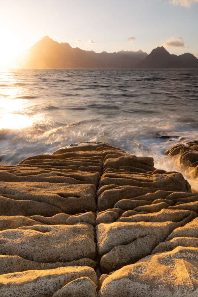
Elgol
Isle of Skye
From Broadford, the B8083 winds across the Strathaird Peninsula, fizzling out at the remote fishing village of Elgol. As you crest a final hill, the single-track road unravels to a tiny harbour where fishing boats lie offshore, silhouetted against the sparkling sea. You’ve reached one of Britain’s most sought-after sunset locations because there, rising directly across the bay in front of you, are the dragon-back mountains of the Black Cuillins.
However, it’s not simply this chiselled backdrop, or the position of the setting sun, that photographers relish here – it’s the fascinating shoreline at Elgol that sees them grappling with tripods long into the dusk.
The cove to the right of the harbour has a band of cobbles that come to life when waves sluice through them on a rising tide. Continue walking along the shore towards a distinctive pale-coloured cliff and, on closer inspection, you’ll find that it’s pitted with holes creating a honeycomb pattern. A little further, rocky ledges have been eroded into undulating furrows and angular blocks. It’s a feast of foreground interest. Deciding what to focus on can be bewildering, which is why it’s so important to get here with enough time to scope out the shoreline, making a note of the features you want to photograph, well before the sun starts to sink and the light improves.
Photography Weekends Britain
For more information, check out Will Gray’s guide to photography weekends in Britain: