Written by Bradt Travel Guides
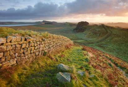
 Hadrian’s Wall spans for 73 miles along England’s neck © duchy, Shutterstock
The 84-mile long-distance trail from Bowness-on-Solway on the Cumbrian coast to Wallsend in Newcastle is fully accessible to walkers and is well signposted. What many visitors would call ‘the best bit’ is the well-preserved section of Wall in the central area, roughly between Chollerford and Brampton. That said, just because the Wall breaks up and often vanishes altogether either side of these settlements isn’t to say the walking is not scenic. The Solway Estuary is birdwatching heaven, and the tumbling farmland through the Tyne Valley is quite dreamy in parts. Even Wallsend has a certain appeal: it is as manmade as Sewingshields Crags is wild, but there is something very raw about the industrial scenery with its cranes and old shipbuilding yards at Swan Hunters.
The Solway Estuary is birdwatching heaven, and the tumbling farmland through the Tyne Valley is quite dreamy in parts.
But, back to ‘the best bit’. Between Sewingshields and Greenhead, the hills rise for 12 spectacular, thigh-busting miles, holding the Wall to the sky and out of the reach of builders of past centuries. On a misty morning when the clouds cover the roads and all signs of modern life, the Wall rollercoasters across the landscape peeking up through bowls of fog wherever the Whin Sill crags rise high enough – it’s evocative moments like this that will stay with the walker.
At any time of year the weather can be foul in the uplands of Northumberland and, just like soldiers 2,000 years ago, you may find yourself huddled under the Wall sheltering from the wind.Chill-proof clothing is recommended throughout the year. Most people walk east to west, usually because Newcastle is better connected than the Cumbrian coast, but there are a few downsides: it’s more likely that you’ll have the wind and rain hitting your front and purists won’t like starting a walk at a place called Wallsend! Make sure you set out with good supplies. You’ll find plenty of villages to refuel at, but you may have to walk perhaps a couple of miles off the Wall in remote parts.
Even though the route is well signposted, you should take OS Explorer maps 314, 315, OL43 and 316. You’ll be grateful when a weather front rolls in.
Hoping to find out more about Northumberland? Why not take a look at our comprehensive travel guide: