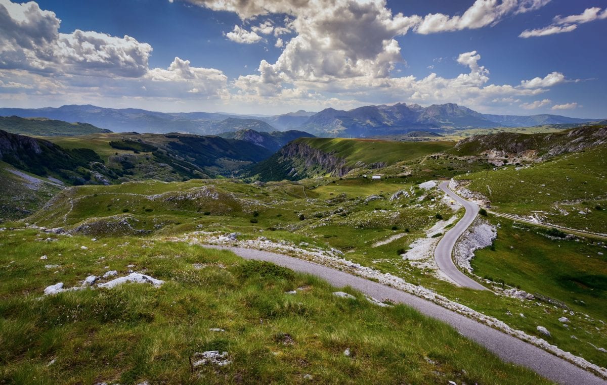
The Dinaric Alps range stretches fiercely across the western Balkans, offering challenging climbs up rugged peaks with epic views or gently rolling hills with wildflower-filled pastures as the mountains level off on the northern face of the range.
Tim Clancy, author of Via Dinarica: the Bradt Guide
Running the length of the Dinaric Alps from Slovenia to Albania, the Via Dinarica is the world’s newest long-distance hiking trail. The three trails – the White, Green, and Blue – are all linked by world-class hiking, biking and rafting routes, and provide opportunities for a huge variety of adventures for nature lovers and extreme sports enthusiasts alike.
The Green and Blue trails are still being developed, but the main White Trail, which follows the highest spine of the Dinarics as it weaves through a large part of the western Balkans, is already operational.
The natural wonders of the Via Dinarica are some of the most diverse, beautiful, and unexplored in Europe: wild rivers, vast limestone caves, dramatic canyons and flower-filled meadows. But along the way you’ll also discover cultural wonders in a landscape where remote highland communities still thrive in their traditional way of living.
One of the most remarkable traits of the Via Dinarica, which sets it apart from other long-distance trails, is that it offers a rare glimpse into ancient cultures that have survived the manifold tests of time.
For more information, check out our guide to Via Dinarica
Food and drink on the Via Dinarica
One of the Via Dinarica’s many unique features is that, unlike other hiking trails that go through remote wilderness, there are frequent opportunities to have a hot meal right along the trail. Because there are countless ancient villages nestled within the nooks and crannies of the Dinaric Alps, the trail offers a real introduction to local lifestyles, including local cuisine as well as the characteristic warm hospitality. Highland food is the truest expression of Balkan food: heavy in bread, heavy in meat, and as local and fresh as can be. Portions tend to be large, and finishing your plate is always considered a sign of good appreciation to the host. Vegetarians may find it challenging to find meatless main dishes, as even some vegetable soups are cooked in meat broth. Bean stew is, however, very popular and very common.
Drinking along the Via Dinarica is also a unique experience. Its defining feature is the famous local alcohol, rakija. This drink, usually translated to English as brandy, is a distilled hard alcohol made from a great variety of fruits and other plants that are prevalent in the Dinaric Alps. Some very common flavours include plum, pear, apple, quince, mixed herbs and honey. You might be offered rakija at every meal, no matter the time of day, as it is considered a natural remedy for many ailments and a great source of vitality when hiking. Your hosts will often join you in a glass of rakija, in another expression of the convivial hospitality of the Balkans.
Beer is also a part of the drinking culture, but with less tradition, and usually less variety. Another interesting traditional drink that you will come across at mountain restaurants is kiselo mlijeko (sour milk) which is a thick, very natural yoghurt that pairs well with salty dishes such as pita and uštipci.
Travel and visas on the Via Dinarica
Getting there and away
By air
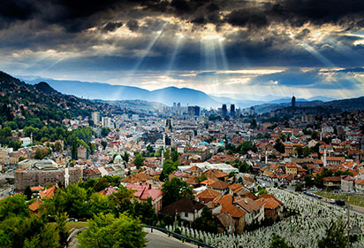
The main airport in Bosnia and Herzegovina is Sarajevo International Airport. There are also international airports in Tuzla and in Mostar. In neighbouring Montenegro there are airports in Podgorica and Tivat (for further information, see montenegroairports.com). Croatia has several international airports, including Franjo Tuđman International Airport on the outskirts of Zagreb, Split International Airport, the international airport of Dubrovnik on the southern coast, and the airport in Rijeka situated on the northern coast and the most convenient airport for the Slovenian starting point of the Via Dinarica trail.
By car
This is the easiest way to get around the Balkans, if you already have access to a car. The roads in Slovenia and Croatia are very good; further south, highways almost disappear and local roads are mountainous and curvy, and almost always only one lane.
Border crossings from Croatia to BiH are slightly different from the crossing(s) from BiH to Montenegro. Croatia is an EU member state and there are no agreements with BiH on mountain crossings for hikers. For this reason, the White Trail was developed to lead to the Croatian border at Kamensko where there is an official crossing. All through-hikers should use this crossing. Between BiH and Montenegro, there are two possibilities. From Sutjeska National Park it is possible to hike into Montenegro via Trnovačko Lake to summit BiH’s highest peak, Maglić. The trail continues from there to Piva Lake and onwards towards Durmitor National Park. The border crossing from Prijevor in Sutjeska National Park to Trnovačko Lake may or may not be monitored by a border guard. It is a generally accepted practice that hikers can enter Montenegro to summit Maglić but it is expected that one returns to Sutjeska National Park after completing the climb. The official border crossing with Montenegro is in Šćepan polje where the Tara and Piva rivers join to create the Drina River.
Getting around
Public transportation in the cities and towns of the Via Dinarica in BiH is efficient and inexpensive, not least because they are all relatively small. Buses are a cheap and convenient way to get around Bosnia and Herzegovina with almost all towns being connected, though asking a local (or the bus driver) for help may be your best way to get information on in-town bus routes. Tickets to ride city buses and trams can be bought from the driver of the vehicle, or from any pavement kiosk around town; they cost between 2KM and 4KM, depending on the city. Although the bus network is extensive, if you are travelling in the more remote parts of the country, you may have to wait up to a day for a bus to come through.
A train service runs from Sarajevo to Mostar daily and stops in Konjic and Jablanica, which are both on the Via Dinarica White Trail.
Taxis are much cheaper in BiH than in western Europe or North America, and unlike in many cities in those continents today, you can hail taxis on the street, and don’t have to look for a taxi rank. Because cities and towns are small and traffic only really exists in the capitals during rush hour, taxis are a very convenient mode of public transportation in the Balkans.
When to visit the Via Dinarica
When to hike
Summer is the most popular season for hiking and climbing in the Dinaric Alps, but the mountains are beautiful throughout the year. Owing to the complex climate influences at play in the region, the seasons vary in different parts of the chain.
Winter
A thick layer of snow covers most of the Central Belt during winter, and most local mountain roads are closed from October to May. For the adventurous of spirit, winter is a great time to hike the Dinaric Alps. It is the least crowded period, the snow can be walked upon after it hardens in January, and the air is the clearest. Winter is also a good time to climb the Maritime Belt, which is usually without snow, and is less crowded than at other times of the year.
Spring
Snow usually remains in the high mountains through the spring, but lower areas become more approachable beginning in March and April. On the coast and in lower Herzegovina, the sun warms the air quickly as spring begins. People swim in the Adriatic Sea as early as April – though, admittedly, mostly only the brave. Late spring is a wonderful time to visit anywhere in the Dinaric Alps, as the flora awakens, plants are in bloom, and light green shades begin to grace the woods and meadows.
Summer
Summer (July–August) is the high season for outdoor activities. Most of the remaining snow melts away in June, and shepherds travel to their summer settlements high in the mountains. This is the time when most tourists visit the mountains, but because it is also the time when most locals travel to the coast, trails are not crowded. It can be very hot and sunny in the Dinaric Alps during the summer, especially in the Maritime and Northeastern belts, as in the Pannonian Plain, and a light mist can often obstruct the full distance of great views. In Mediterranean areas, be careful to carry enough water at all times, consider taking breaks during the middle of the day, and do not expect much shade or other relief from high temperatures. August is the month with the lowest average rainfall in high-altitude areas.
Autumn
Early autumn is a lovely time to explore the Dinaric Alps. Temperatures cool but remain warm, forests become alive with colour and high mountain meadows turn golden-yellow. The weather changes in late autumn, which is by far the rainiest period, and is accompanied by pervasive fog. Mountain peaks remain under clouds for days or even weeks, and receive higher amounts of precipitation than lower areas. In November and especially in December, winter temperature inversions begin, which are characterised by higher air pressure pushing long-lasting cold fogs into the valleys and lowlands, leaving mountaintops clear and sunny – classic conditions for the Balkan ski season!
What to see and do on the Via Dinarica
 Blidinje Lake in Blidinje Nature Park © Elma Okić
Blidinje Nature Park
Blidinje Nature Park is a visually stunning environment. The impressive natural endowments of the park include the highest summits of Vran Mountain, including Veliki Vran at 2,074m, and Vran, which has an altitude of 2,020m. Additionally, the park has some interesting cultural heritage to explore, including Saint Elijah’s Church, an artistically decorated church of St Elias, and Masna Luka, a Franciscan monastery located at an altitude of 1,200m. Near the Hajdučke Vrleti motel in the middle of the valley there is a necropolis of stećci, part of the UNESCO World Heritage Site.
Blidinje’s vast valley is a popular summer destination for hikers and mountain bikers with the heart of the Via Dinarica trail covering both Vran and Cvrsnica Mountains. In the winter time, Via Dinarica is exciting for snow shoeing and tour skiing, but also for skiing at Risovac. It is one of the most remote nature parks in southeast Europe.
Boračko jezero
Boračko jezero is a semi-glacial body of water set in the mountains in the central part of the Via Dinarica White Trail. It is an excellent place to rest after the long and challenging stages over Čvrsnica and Prenj mountains. The lake is open to the public for camping, swimming and barbecues, and a few of the locals have opened bed and breakfasts along the shores; there are also campsites. It costs 2KM per person to get into the lake area; the best spot is across the lake by the restaurant where you will find a great freshwater stream and plenty of shade. Swimming in the lake is highly recommended in the summer months. Boračko jezero is also a good place to take a day’s break and go whitewater rafting on the Neretva River. About 5km away, the area between Konjic and the village of Glavetičevo is marked as campsites for the rafting companies that run trips down the Neretva Canyon.
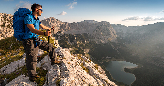 A birds-eye view of Trnovačko Lake in Montenegro near Bosnia’s highest peak, Maglić © Adnan Bubalo
Sutjeska Natural Park
Sutjeska National Park is the oldest and largest national park in Bosnia and Herzegovina. There are a handful of must-sees while in the park. Perućica Nature Reserve is home to one of the last remaining primeval forests in Europe, and where any element of human intervention has been forbidden since the National Park was established. There are a number of impressive mountains: Volujak, Vučevo, Zelengora and Maglić, the last of which is the highest peak in Bosnia and Herzegovina, at 2,386m. There are two highly recommended viewpoints: Borić viewpoint, from where you can see the Sutjeska River Canyon, the mountains of Vučevo, Maglić and Volujak, Perućica rainforest, the mountain passes of Dragoš sedlo and Prijevor, the Tjentište Valley, and remnants of the ancient cities of Vratar and Vrata; and Prijevor viewpoint at 1,668m, from where Maglić towers overhead and a whole chain of Dinaric peaks spreads in front of you.
There also two lakes: Donje Bare, a lake on Zelengora Mountain; and Trnovačko jezero (Trnovačko Lake) at 1,517m, which lies beneath the heights of Maglić and is best known for its heart-like shape and deep green-blue colour.
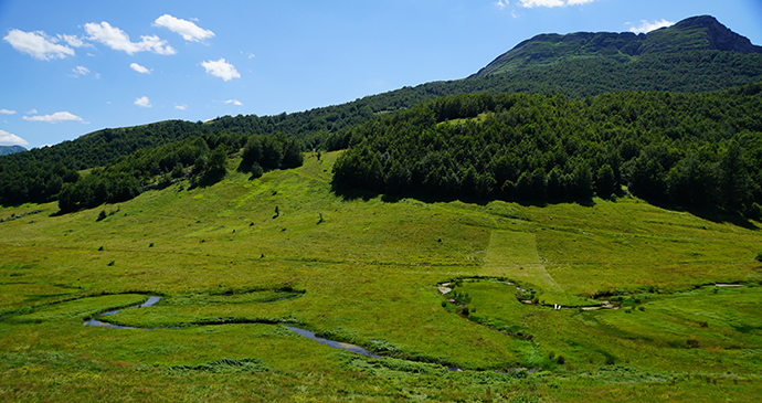 The serpentine creek of Studeni potok near the village of Umoljani © balkanyrudej, Shutterstock
Umoljani
Although this highland village was destroyed during the war, much of it has been rebuilt. The natural beauty of its surroundings, though, is still among the most striking in the area. The south side is a typical karst landscape that is dry and rather barren; the north side is lush with thick forest and green pastures and is ideal for hiking, walking or a picnic. The tombstones of ancient settlers can be found scattered around the village, with many medieval tombstones perched on high ridges.
During Ottoman times, Umoljani had to face its own demons. There were rumours of a dragon-like creature roaming the foothills of Obalj Mountain. Some shepherds swore they saw it, others claimed to have lost sheep to the creature. The villagers were panic-stricken. The local Muslim priest (hodža) decided to go and find this dragon. He expected to find nothing but asked the villagers to pray for him while he was gone. For days, there was no sign of the hodža and the scared villagers diligently prayed. Then, as the tale goes, the hodža met the beast just above the shepherds’ summer huts. He, too, used prayer as his main weapon, and in an instant the dragon was frozen in stone on top of the mountain. The hodža returned with news that he had defeated the dragon. He gave credit to the faith and prayers of the villagers for his impossible victory and named the village Umoljani, meaning ‘Of the prayers’. On a peak just above the village of Umoljani is a rock formation that very much resembles a dragon.
Related books
For more information, see our guide to Via Dinarica:
Related articles
Europe has some spectacular opportunities for walkers.
These are the best places to start or finish your journey along the Via Dinarica.
From caving to kayaking and hiking to biking, this brand new Baltic hiking route has plenty of adrenalin-pumping pursuits to inspire any outdoor enthusiast.