Trotternish has Skye’s most iconic landscapes and there are many unexpected beautiful places (although, alas, the Old Man of Storr is somewhat a victim of its glowing reputation). With endless hiking opportunities, towering cliffs, fossilised dinosaur footprints, abandoned villages and secret archaeology, you could spend weeks in Trotternish and barely scratch the surface.
It is important to note that there is hardly any phone signal anywhere on Trotternish, making some amount of forward planning, an OS map and/or a GPS device, essential.
With such dramatic scenery, it’s a shame to rush through Trotternish. From strenuous hikes to easy footpaths, there are infinite walking opportunities and, for many people, exploring on foot is the most rewarding way to enjoy the landscape. Though the stretch of road between Portree and the Old Man of Storr can be busy, cyclists who do not mind the odd hill will love the northern half of Trotternish. With the Skye Bridge as an open gateway, hitchhiking is arguably a little less safe than on the smaller islands, but crime is still very uncommon and hitchhiking is very easy.
The east coast
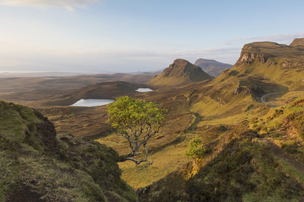
Travelling north from Portree on the A855, the landscape quickly becomes mountainous and the Storr, the range of mountains behind the Old Man of Storr, soon comes into view. Around 4 miles north of Portree, you pass the lovely lochs of Fada and Leathan, before reaching the car park for the Old Man of Storr.
The uphill walk to reach this famous rock pinnacle is just under 3 miles return, with an elevation gain of 935ft. Although the route starts (from the car park) on a substantial track, it diminishes into an anarchy of trodden paths, muddy in places and not always particularly clear; sturdy boots and a bottle of water are recommended, along with appropriate clothing for the weather. In high season it is best to arrive early or late to enjoy your visit without the crowds that throng here for most of the day.
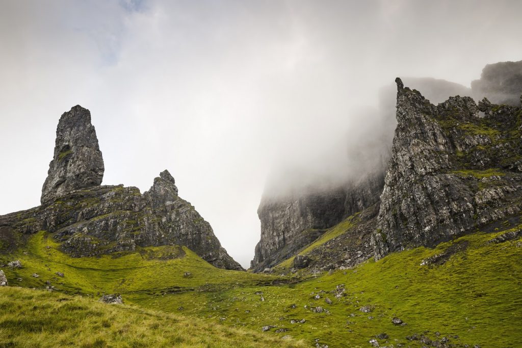
As much as I would like to tell you the Storr is an over-hyped destination, it really isn’t the case; the ‘Old Man’ (a somewhat miraculous pointed rock stack) and the whole surrounding mountain range are incredible. Given just the right amount of mist, clouds shift slightly to reveal different crags, and a dampening silence descends over the area. It is tempting to walk between the cliffs and stacks of rock, but remember that this whole area has been formed by landslides and falling rocks are a distinct possibility.
Further north is Lealt Falls (An Lethallt). A popular stop along the road, there is a large car park here with a wooden platform in place to give you a great view over the waterfall and canyon. At the bottom of the cliffs, on the shore, are the remains of a 19th-century diatomite works. Skye diatomite is a silica-rich sediment formed by microscopic algae and was of interest for its potential use in the production of dynamite during the 1880s. The iron-roofed construction on the south of the river is a disused salmon fishing station.
Northern Trotternish
At Kilt Rocks and Mealt Falls is a large car park and a viewing point over the towering cliffs. With dramatic basalt columns, named for their resemblance to the pleats of a kilt, and a narrow waterfall plummeting 196ft down to the sea, this quick stop is a favourite with photographers. Take some time to scan the sea for dolphins, porpoises and other marine mammals.
Nearby is the Staffin Dinosaur Museum, a small museum in a traditional cottage with an amazing collection of dinosaur fossils and information. This is also the best place to ask for advice about finding footprints in the area.
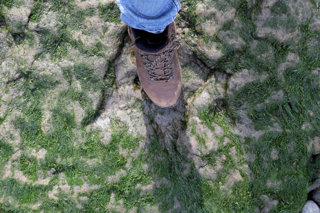
Although it is well known that there are dinosaur footprints on An Corran beach near Staffin, this fact does not make them any easier to find (roughly n 57°38’13.8”N 6°12’17.4”W). There is an interpretation board at the car park here, but it is worth studying the photo to see what you are looking for, as the map is quite inaccurate. To find them, head down the ramp that runs from the car park to the beach; they are about 5yds east (towards the sea) from the lowest boulder on the ramp.
The footprints have three toes, each around the same size as a human foot, and are positioned as if the creature was walking towards the sea. They are set into rock, which looks like the fossilised ripples of a sand bed; this rock is covered with green algae, which might make them difficult to distinguish; at times the tide brings up sand, making them impossible to see. Depending on the conditions, an adventurous person in a sturdy wheelchair could potentially access this site.
The west coast
The oldest parts of Duntulm Castle were built in the 14th and 15th centuries; what’s left of it sits in a dramatic clifftop position on the west coast, not far from where the ring road starts to head south. Th is area saw many years of feuding between the MacDonalds (of Sleat) and the MacLeods until it settled as the seat of MacDonalds in the 17th century.
In 1732 Sir Alexander MacDonald was looking for something a bit more comfortable and robbed the stones from Duntulm to build his new residence Monkstadt House, 6 miles further south. There is a place to park at the corner of the road and the castle ruins are a short walk away on a grassy path. Be sure to look down at the sea as an otter lives along this coastline and you might even see porpoises or dolphins.